IMAGES TAKEN NEAR TO
Marigold Close, SHEFFIELD, S5 6FA
Introduction
This page details the photographs taken nearby to Marigold Close, S5 6FA by members of the Geograph project.
The Geograph project started in 2005 with the aim of publishing, organising and preserving representative images for every square kilometre of Great Britain, Ireland and the Isle of Man.

There are currently over 7.5m images from over14,400 individuals and you can help contribute to the project by visiting https://www.geograph.org.uk
Image Map
Images are licensed for reuse under creativecommons.org/licenses/by-sa/2.0
Notes
- Clicking on the map will re-center to the selected point.
- The higher the marker number, the further away the image location is from the centre of the postcode.
Image Listing (30 Images Found)
Images are licensed for reuse under creativecommons.org/licenses/by-sa/2.0
Image
Details
Distance
1
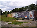
Mural behind the garages at Clover Gardens
For more street art see Image
Image: © Martin Speck
Taken: 1 Aug 2010
0.12 miles
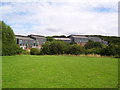
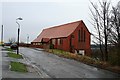
2
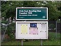
Firth Park Bowling Club, Firth Park, Sheffield
Image: © Terry Robinson
Taken: 23 Aug 2013
0.17 miles
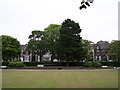
3
View to the Club House, Firth Park Bowling Club, Firth Park, Sheffield
Image: © Terry Robinson
Taken: 23 Aug 2013
0.17 miles
4
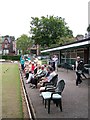
Spectators at the ready, Firth Park Bowling Club, Firth Park, Sheffield
Image: © Terry Robinson
Taken: 23 Aug 2013
0.18 miles
5
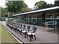
Seats at the ready, Firth Park Bowling Club, Firth Park, Sheffield
Image: © Terry Robinson
Taken: 23 Aug 2013
0.18 miles
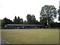
6
View across the Green, Firth Park Bowling Club, Firth Park, Sheffield - 2
Image: © Terry Robinson
Taken: 23 Aug 2013
0.18 miles
7
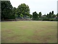
View across the Green, Firth Park Bowling Club, Firth Park, Sheffield - 1
Image: © Terry Robinson
Taken: 23 Aug 2013
0.18 miles
8
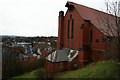
The south end of St Hilda's
For a fuller shot see Image
Image: © David Lally
Taken: 2 Jan 2010
0.18 miles
9
St Hilda's, Windmill Lane
Now abandoned Anglican Church. The building utilised the steep hill on which it stands well. The top-floor, level with the road, was the church, while the basement floor beneath housed the vestry and church hall. I only know this because I used to attend a badminton club in the hall.
Image: © David Lally
Taken: 2 Jan 2010
0.20 miles