IMAGES TAKEN NEAR TO
Hinde Street, SHEFFIELD, S4 8HJ
Introduction
This page details the photographs taken nearby to Hinde Street, S4 8HJ by members of the Geograph project.
The Geograph project started in 2005 with the aim of publishing, organising and preserving representative images for every square kilometre of Great Britain, Ireland and the Isle of Man.

There are currently over 7.5m images from over14,400 individuals and you can help contribute to the project by visiting https://www.geograph.org.uk
Image Map
Images are licensed for reuse under creativecommons.org/licenses/by-sa/2.0
Notes
- Clicking on the map will re-center to the selected point.
- The higher the marker number, the further away the image location is from the centre of the postcode.
Image Listing (17 Images Found)
Images are licensed for reuse under creativecommons.org/licenses/by-sa/2.0
Image
Details
Distance
2
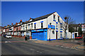
Pakistan Community Centre
On Page Hall Road.
This was a pub the Firth Park Hotel until a couple of years ago and the pub sign has been left in place.
Image: © David Lally
Taken: 17 Apr 2010
0.14 miles
3
Double Diamond off-licence
On Page Hall Road.
Recently had new signs and a rather drastic paint job, but still retains the name. It originated from the Indcoop bottled beer of same name.
Image: © David Lally
Taken: 17 Apr 2010
0.16 miles
4
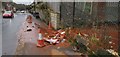
Rusty water or natural spring?
Flowing from a corner of a disused industrial unit on Upwell Street.
From staining at this point, and for 200 or more yards down the road, it's been running for some time.
Sad to say Grimesthorpe rather lives up to the name with all the litter scattered everywhere in this area.
Image: © Chris Morgan
Taken: 2 Jan 2020
0.18 miles
5
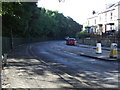
Bend on Firth Park Road (B6086)
Heading south.
Image: © JThomas
Taken: 27 Sep 2014
0.20 miles
7
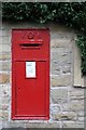
Victorian Post Box
This quite large Victorian Post Box is at the junction of Bolsover Rd and Firth Park Road.
It looks like the wall has been rebuilt quite recently - or maybe it has just been cleaned
Image: © David Lally
Taken: 7 Oct 2007
0.21 miles
8
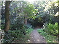
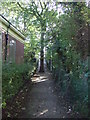
Stepped Snicket above Firth Park Road
An older paved path is also in use here. The trees are a surviving fragment of Wincobank Wood.
Image: © Jonathan Clitheroe
Taken: 12 Apr 2013
0.21 miles
9
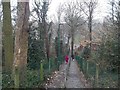
Path beside library
Heading east from Firth Park Road.
Image: © JThomas
Taken: 27 Sep 2014
0.22 miles
10
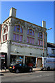
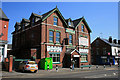
Khawaja and Sons - Halal Supermarket
Build as a Co-op shop in about 1910 (I expect that would have been the Brightside and Carbrook Co-op). It was, through the 1960s and part of the 1970s a furniture shop by the name of Patnic (or Patnik). Then a local DIY shop called Pope's moved in and they must have still be in residence in 1995 as it was grade II listed in that year and is described as a DIY shop.
List entry Number: 1246876 https://historicengland.org.uk/listing/the-list/list-entry/1246876
Image: © David Lally
Taken: 17 Apr 2010
0.22 miles