IMAGES TAKEN NEAR TO
Cutlers Gate, SHEFFIELD, S4 7TL
Introduction
This page details the photographs taken nearby to Cutlers Gate, S4 7TL by members of the Geograph project.
The Geograph project started in 2005 with the aim of publishing, organising and preserving representative images for every square kilometre of Great Britain, Ireland and the Isle of Man.

There are currently over 7.5m images from over14,400 individuals and you can help contribute to the project by visiting https://www.geograph.org.uk
Image Map
Images are licensed for reuse under creativecommons.org/licenses/by-sa/2.0
Notes
- Clicking on the map will re-center to the selected point.
- The higher the marker number, the further away the image location is from the centre of the postcode.
Image Listing (242 Images Found)
Images are licensed for reuse under creativecommons.org/licenses/by-sa/2.0
Image
Details
Distance
1
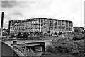
Looking over Park Square
Parkhill flats a work still in progress.
Image: © dave hudson
Taken: 24 Jun 2011
0.06 miles
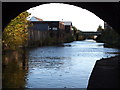
2
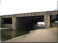
Victoria and Wicker Viaducts
The original arched central span of this railway viaduct over the Sheffield & Tinsley Canal was later added to on both sides with straight steel spans. This was the main line of the Great Central Railway through Sheffield (Victoria) nearby Image to Manchester. It would at one time have had at least four, possibly six tracks. Now only one track remains, serving the Stocksbridge Steelworks some distance away Image
Image: © Stephen Craven
Taken: 3 Apr 2012
0.09 miles
3
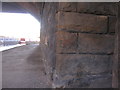
Benchmark under the railway between the canal and Blast Lane
Image: © John Slater
Taken: 18 Nov 2012
0.10 miles
4
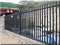
Fence panels made of crimped tubes
The wall and railings separate Blast Lane from the towpath of the Sheffield & Tinsley Canal. The bridge in the background carries Cutlers Lane A61.
Image: © Robin Stott
Taken: 3 Apr 2012
0.10 miles
5
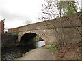
Cadman Street Bridge
For a view from the opposite direction of this road bridge over the canal, see Image It was built in 1819 to the designs of William Chapman, and is grade 2 listed.
Image: © Stephen Craven
Taken: 3 Apr 2012
0.10 miles
6
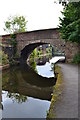
Cadman Street Bridge (1819) - Sheffield and Tinsley Canal
Image: © Neil Theasby
Taken: 12 Aug 2012
0.10 miles
7

Chimney reflection in The Sheffield and Tinsley Canal
Near the Derek Dooley Way road bridge
Image: © Neil Theasby
Taken: 2 Jan 2017
0.10 miles
8
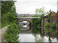
Cadman Bridge over Sheffield and Tinsley Canal
Cadman bridge looking in the direction of Victoria Quays. In front of the bridge a pipe crosses the canal, on the right bank is a derelict former industrial building.
Image: © Graham Robson
Taken: 16 May 2007
0.10 miles
9
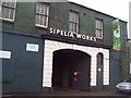
The Sipelia Works on Cadman Street
Built in the mid 19th century and home to Adam Engineering at the time of posting. Some may also recognise this scene from the video to the Arctic Monkeys' song 'When the Sun Goes Down'.
Image: © Jonathan Clitheroe
Taken: 21 Feb 2011
0.10 miles
10
Sheffield, S1 - Canal
A view along the Sheffield and Tinsley canal towards Tinsley, as seen through Cadman Bridge (built 1819). The Sheffield Canal Basin lies behind the photographer. The canal runs 3.9 miles (6.3kms) from the River Don, Tinsley to the city centre canal basin (renamed "Victoria Quays"), passing through 11 locks.
Image: © David Hallam-Jones
Taken: 27 Oct 2012
0.10 miles