1
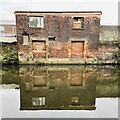
The Sipelia Works on Cadman Street
Built in the mid 19th century and home to Adam Engineering at the time of posting. Some may also recognise this scene from the video to the Arctic Monkeys' song 'When the Sun Goes Down'.
Image: © Jonathan Clitheroe
Taken: 21 Feb 2011
0.03 miles
2
Sheffield and Tinsley Canal
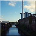
A view from a train stopped outside Sheffield Midland station.
Image shows the same stretch of canal looking the other way from Cadman Street bridge.
Image: © Stephen Craven
Taken: 8 Feb 2020
0.04 miles
3
Sheffield, S1 - Canal
The old and the new. A stretch of the Sheffield and Tinsley canal in the Tinsley direction taken from Cadman Street as it passes over Cadman Bridge. The canal runs 3.9 miles (6.3 km) from the River Don, Tinsley to the city centre canal basin (renamed "Victoria Quays"), passing through 11 locks.
Image: © David Hallam-Jones
Taken: 27 Oct 2012
0.04 miles
4
Sheffield, S1 - Canal
A view along the Sheffield and Tinsley canal towards Tinsley, as seen through Cadman Bridge (built 1819). The Sheffield Canal Basin lies behind the photographer. The canal runs 3.9 miles (6.3kms) from the River Don, Tinsley to the city centre canal basin (renamed "Victoria Quays"), passing through 11 locks.
Image: © David Hallam-Jones
Taken: 27 Oct 2012
0.04 miles
5
Sheffield, S1 - Canal
A number of canal mooring points in the vicinity of the canal basin visible on each side of Cadman Bridge (built 1819). The Sheffield basin is a minute's walk through the tunnel, whereas the Tinsley direction is behind the photographer. The canal runs for 3.9 miles (6.3kms) from the River Don, Tinsley to the city centre canal basin (renamed "Victoria Quays"), passing through 11 locks.
Image: © David Hallam-Jones
Taken: 27 Oct 2012
0.04 miles
6
Refuse lorries and electric locomotives at Sheffield
Refuse lorries of the then Sheffield Corporation Cleansing depart in the yard at the refuse destruction, now replaced by a modern incineration and generation plant. https://www.geograph.org.uk/photo/5656820 . The locomotives are two of the EM1 class BoBo 1500V DC locomotives built for the Woodhead line between Sheffield and Manchester.
The refuse lorries were at the time only an incidental to the locomotives, which were the reason for taking the picture, but it is instructive to see how the design of such vehicles has changed over the years.
Image: © Alan Murray-Rust
Taken: 20 Apr 1965
0.04 miles
7
Sheffield and Tinsley canal
Image: © Dave Pickersgill
Taken: 5 Nov 2022
0.04 miles
8
Under Cadman Street Bridge
By The Sheffield and Tinsley Canal
Image: © Neil Theasby
Taken: 30 Sep 2019
0.04 miles
9
Cadman Bridge over Sheffield and Tinsley Canal
Cadman bridge looking in the direction of Victoria Quays. In front of the bridge a pipe crosses the canal, on the right bank is a derelict former industrial building.
Image: © Graham Robson
Taken: 16 May 2007
0.04 miles
10
By the Sheffield & Tinsley Canal
It is interesting to walk from Sheffield's Canal Basin all the way to Tinsley. Along the way you see many images like this that speak of the canal's long history.
Image: © Neil Theasby
Taken: 30 Sep 2019
0.05 miles


