IMAGES TAKEN NEAR TO
Dunvegan Avenue, CHESTERFIELD, S45 9SP
Introduction
This page details the photographs taken nearby to Dunvegan Avenue, S45 9SP by members of the Geograph project.
The Geograph project started in 2005 with the aim of publishing, organising and preserving representative images for every square kilometre of Great Britain, Ireland and the Isle of Man.

There are currently over 7.5m images from over14,400 individuals and you can help contribute to the project by visiting https://www.geograph.org.uk
Image Map
Images are licensed for reuse under creativecommons.org/licenses/by-sa/2.0
Notes
- Clicking on the map will re-center to the selected point.
- The higher the marker number, the further away the image location is from the centre of the postcode.
Image Listing (11 Images Found)
Images are licensed for reuse under creativecommons.org/licenses/by-sa/2.0
Image
Details
Distance
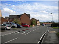
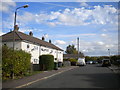
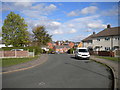
1
Danesmoor housing estate from footpath to the east
View of houses from a path - the view is mainly obscured by tall thick hedges.
Image: © Andrew Hill
Taken: 27 May 2011
0.08 miles
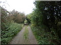
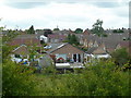
7
Lime Tree Grove, Danesmoor
The first view of houses in Danesmoor from the track approaching from the east.
Image: © Andrew Hill
Taken: 27 May 2011
0.15 miles
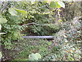
9
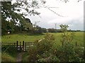
Public Footpath at Spring Vale, Clay Cross
Looking over a waterlogged field from the southern fringe of Clay Cross.
Image: © Jonathan Clitheroe
Taken: 26 Sep 2012
0.16 miles