IMAGES TAKEN NEAR TO
Slacks Lane, CHESTERFIELD, S45 8HH
Introduction
This page details the photographs taken nearby to Slacks Lane, S45 8HH by members of the Geograph project.
The Geograph project started in 2005 with the aim of publishing, organising and preserving representative images for every square kilometre of Great Britain, Ireland and the Isle of Man.

There are currently over 7.5m images from over14,400 individuals and you can help contribute to the project by visiting https://www.geograph.org.uk
Image Map
Images are licensed for reuse under creativecommons.org/licenses/by-sa/2.0
Notes
- Clicking on the map will re-center to the selected point.
- The higher the marker number, the further away the image location is from the centre of the postcode.
Image Listing (130 Images Found)
Images are licensed for reuse under creativecommons.org/licenses/by-sa/2.0
Image
Details
Distance
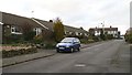
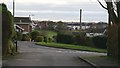
1
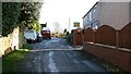
Slack's Lane
Slack's Lane looking towards its junction Image with Forest Drive Image
Behind the viewpoint the lane curves right to join Bridge Street Image
Also behind the viewpoint, but to the left, is Image
Image: © Alan Walker
Taken: 10 Jan 2007
0.01 miles
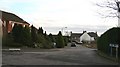
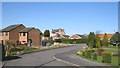
2
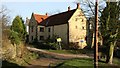
Barlow Bank Farm
Prior to 1800, Pilsley was purely an agricultural settlement and at that time it consisted of Upper Pilsley and Nether Pilsley. Few of the houses from that period still exist though Barlow Bank Farm (no longer a farm building) is one of them.
The building is situated near to the junction of Slack’s Lane (seen on the right of the photograph Image) and the northern end of Bridge Street Image
Image: © Alan Walker
Taken: 10 Jan 2007
0.02 miles
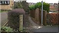
3
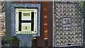
Fire hydrant and signage
This Fire hydrant and its signage are on Slack’s Lane roughly half way between its junction with Forrest Drive and where it meets The Paddocks Image and Back Lane Image
Image: © Alan Walker
Taken: 10 Jan 2007
0.03 miles
4
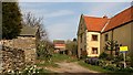
Barlow Bank Farm
Although now just a private dwelling, the house on the right (for sale at the time this photograph was taken) is still called Barlow Bank Farm.
The photograph was taken from the western end of Image (to the left) at its junction with Image (behind the viewpoint).
Ahead (north-easterly, leading toward the modern house) is a Image leading to Image
Image: © Alan Walker
Taken: 2 Apr 2007
0.03 miles
5
Slack's Lane
The photograph is taken from the point where the lane Image meets Forest Drive Image
At the head of the road (right, distance) is Back Lane Image where it meets The Paddocks Image
To the right of this viewpoint is a Image that leads, via Rother Street and Queen Street to Station Road.
Image: © Alan Walker
Taken: 11 Jan 2007
0.04 miles
6
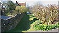
Right of Way
This right of way connects Image (behind the viewpoint) Image at its junction with Image
The building with the tiled roof is Image
Image: © Alan Walker
Taken: 5 Apr 2007
0.04 miles
7
Old Hall Close
Image from its junction with Back Lane Image
The junction in the middle distance (right) is with Image
The building with the white gable end is ‘Old Whitehall’. In front of this building is a right of way that leads past Image to Image at its junction with Image
Image: © Alan Walker
Taken: 12 Jan 2007
0.05 miles
8
Footpath
Before more modern housing was built the left-hand side of this photograph was a field and the path ran down its edge. This path was one of those that the miners would have used on their way to the colliery entrance. Today the path runs to Image via Rother Street and a children’s playing field.
To see a more southerly (ahead) view of this footpath at its junction with Rother Street, click here: Image
Click here Image for a view of Slack's Lane taken from the same viewpoint.
Image: © Alan Walker
Taken: 11 Jan 2007
0.05 miles
9
Back Lane
The photograph shows Back Lane at the point where its junctions with Image (turning right) and Image (across the white lines) detach a short section of Image from the majority of its length.
Behind the viewpoint the lane continues Image towards Whitehall Farm.
Image: © Alan Walker
Taken: 12 Jan 2007
0.05 miles
10
Old Hall Close
The cul-de-sac, Old Hall Close, photographed from near its southern end.
The junction in the middle distance (left) is with Image
The northern end of Image joins Image ahead (but out of shot).
Just past the shadow, on the near left, is a Image
Image: © Alan Walker
Taken: 5 Apr 2007
0.05 miles