IMAGES TAKEN NEAR TO
Lansbury Avenue, CHESTERFIELD, S45 8EH
Introduction
This page details the photographs taken nearby to Lansbury Avenue, S45 8EH by members of the Geograph project.
The Geograph project started in 2005 with the aim of publishing, organising and preserving representative images for every square kilometre of Great Britain, Ireland and the Isle of Man.

There are currently over 7.5m images from over14,400 individuals and you can help contribute to the project by visiting https://www.geograph.org.uk
Image Map
Images are licensed for reuse under creativecommons.org/licenses/by-sa/2.0
Notes
- Clicking on the map will re-center to the selected point.
- The higher the marker number, the further away the image location is from the centre of the postcode.
Image Listing (145 Images Found)
Images are licensed for reuse under creativecommons.org/licenses/by-sa/2.0
Image
Details
Distance
1
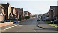
Lansbury Avenue
The photograph shows Lansbury Avenue and was taken from its northern (cul-de-sac) end.
To the right is an Image to a field and footpath.
Behind the viewpoint and to the left of the photograph is the exit from a Image that carries the infant River Rother under the village from the eastern side.
To see a photograph of Lansbury Avenue taken from a few metres ahead of this viewpoint, but looking back in the opposite (northerly) direction, click here Image
To see a more southerly (ahead) photograph of Lansbury Avenue, but looking back toward this viewpoint, click here Image
Image: © Alan Walker
Taken: 1 Feb 2007
0.01 miles
2
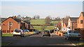
Lansbury Avenue
The photograph shows the newer section of Lansbury Avenue running in a north north-westerly direction.
In the foreground of the picture is the turning circle at, what used to be, the end of the cul-de-sac.
The middle ground shows some of the new housing in the extension to the cul-de-sac.
Across the fields, in the distance, can be seen a Image that runs from the end of Lansbury Avenue to Image
For a more northerly (ahead) photograph of Lansbury Avenue, click here Image
For a more southerly (behind the viewpoint) photograph of Lansbury Avenue, click here Image
Image: © Alan Walker
Taken: 1 Feb 2007
0.03 miles
3
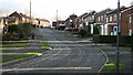
Queensway
The photograph shows Queensway. The road joining from the left (just ahead of the pedestrian) is Image
The Image on the left are typical of many built in the village.
To see a photograph from near to, but behind, this viewpoint, looking in the opposite direction, click here Image
To see a more northerly (behind the viewpoint) photograph of Queensway looking back, toward the viewpoint, from Queensway’s junction with Pear Tree Road click here Image
To see a more southerly (ahead) photograph of Queensway but looking back, toward this viewpoint, click here Image
Image: © Alan Walker
Taken: 22 Jan 2007
0.03 miles
4
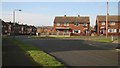
Lansbury Avenue
The photograph shows Image (foreground and to the left) at its junction with Image
A few metres behind the viewpoint is the avenue’s Image with Image
To see another photograph (in the opposite direction) of this junction, click here Image
To see a more north-westerly (ahead) photograph of Lansbury Avenue, click here Image
Image: © Alan Walker
Taken: 1 Feb 2007
0.04 miles
5
View over field
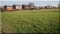
This photograph shows the view over a field toward the rear of houses on the south-western side of Image
The photograph was taken from a footpath that heads onward and off the left hand side of the photograph to an Image with Image
To see a photograph of the footpath taken from a more south-westerly (behind the viewpoint) position, click here Image
Image: © Alan Walker
Taken: 1 Feb 2007
0.05 miles
6
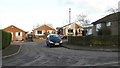
Damon Close
Image: © Alan Walker
Taken: 22 Jan 2007
0.06 miles
7
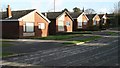
Bungalows
These bungalows on Image are typical many built in the village.
Image: © Alan Walker
Taken: 22 Jan 2007
0.06 miles
8
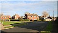
Lansbury Avenue
The photograph shows Lansbury Avenue (foreground and to the right) at its junction with Image
To the right is the avenue’s Image with Image
To see another view (in the opposite direction) of this junction, click here Image
To see a more north-westerly (behind the viewpoint) view of Lansbury Avenue, click here Image
Image: © Alan Walker
Taken: 1 Feb 2007
0.06 miles
9
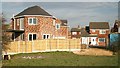
Entrance
The photograph shows the entrance to Image from a field to the southwest of the avenue.
This entrance also carries a public footpath from Lansbury Avenue along the north-western edge of the field (behind the viewpoint) that links with others leading to Padleywood Farm, Pilsley Green, Hallgate lane and elsewhere.
For a metre or so the grounds of the new dwelling (left and Centre) are built over the infant River Rother.
To see a photograph taken from a more south-westerly (behind the viewpoint) position along the footpath, click here Image
Image: © Alan Walker
Taken: 1 Feb 2007
0.06 miles
10
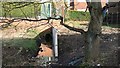
Culvert
The photograph, taken from close by the end of Image, shows the exit of the culvert that carried the infant River Rother from Image under the central part of the village.
To see the upstream entrance to the culvert, click here Image
To see a downstream photograph of the River Rother (westerly and more attractive!), click here: Image
Image: © Alan Walker
Taken: 1 Feb 2007
0.07 miles