IMAGES TAKEN NEAR TO
Highoredish, CHESTERFIELD, S45 0JY
Introduction
This page details the photographs taken nearby to Highoredish, S45 0JY by members of the Geograph project.
The Geograph project started in 2005 with the aim of publishing, organising and preserving representative images for every square kilometre of Great Britain, Ireland and the Isle of Man.

There are currently over 7.5m images from over14,400 individuals and you can help contribute to the project by visiting https://www.geograph.org.uk
Image Map
Images are licensed for reuse under creativecommons.org/licenses/by-sa/2.0
Notes
- Clicking on the map will re-center to the selected point.
- The higher the marker number, the further away the image location is from the centre of the postcode.
Image Listing (23 Images Found)
Images are licensed for reuse under creativecommons.org/licenses/by-sa/2.0
Image
Details
Distance
1
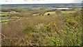
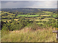
From Highoredish looking towards Ogston Reservoir
Image: © Chris Morgan
Taken: 23 Mar 2015
0.04 miles
2
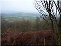
Not much of a view from Coldharbour Lane
On a misty morning looking towards Ashover Hay.
Image: © Peter Barr
Taken: 22 Nov 2010
0.05 miles
3
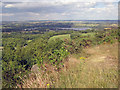
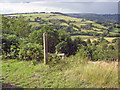
Highoredish viewpoint - 1
Just off Coldharbour Lane are parking spaces, a picnic site and seats affording a great view to the north across Ashover and beyond. Looking to the north-east is Ogston Reservoir and beyond is Stretton, Pilsley, Hardwick Hall and parts of the Sherwood Forest. Above the left end of the reservoir is Bolsover (castle easily spotted) and beyond are the great forests around Clumber and Welbeck.
Image
Image: © Trevor Rickard
Taken: 17 Jul 2010
0.08 miles
4
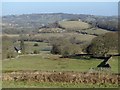
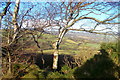
View near Highoredish Farm
The farm is off to the right. The hill below the skyline centre right is Ashover Hay.
Image: © Andrew Hill
Taken: 2 Mar 2013
0.09 miles
5
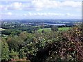
Highoredish viewpoint - 2
From the viewpoint on the gritstone ridge west of Brackenfield looking north across the Amber valley towards Ashover Hay. Just left of centre in the middle distance is the ridge of Ravensnest Tor and the cliff face of Milltown Quarry.
Image
Image: © Trevor Rickard
Taken: 17 Jul 2010
0.15 miles
6
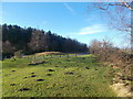
Silver Birch at High Oredish
View from the car park at High Ordish picnic site
Image: © norman griffin
Taken: 28 Dec 2013
0.15 miles
7
Ogston reservoir from High Ordish
View from the car park at High Ordish towards the reservoir near Brackenfield.
Image: © norman griffin
Taken: 12 Sep 2010
0.16 miles
8
High Ordish picnic site
View of car park.
Image: © norman griffin
Taken: 28 Dec 2013
0.16 miles
9
Highoredish viewpoint - 3
View north-west to the dome of farmland above Butterley. On the extreme left is Butterley Top Farm.
Image
Image: © Trevor Rickard
Taken: 17 Jul 2010
0.16 miles
10
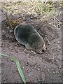
Mole Digging a Hole
Mole found wandering / scratching on tarmac car park at Highoredish, placed back onto earth pile where it continued to dig.
Image: © Alan Heardman
Taken: 16 Jul 2000
0.17 miles