1
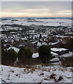
Carr Vale and beyond
Taken from Bolsover 'Back Hills', Carr Vale village is the farthest extent of the housing in the foreground. Beyond that is the water of Carr Vale Flash wildfowl habitat, then the M1 motorway dividing the cornfields, and at the top of the far cornfield, amid the trees, is the ruinous Sutton Scarsdale Hall. On the far horizon is Ashover Rock. Contrast this view with contributor Andrew Hall's
Image taken from almost the same spot.
Image: © Gordon Elliott
Taken: 11 Aug 2010
0.04 miles
2
Towards the top of Bainbridge Road
A modern housing estate is spread across the hillside below the town centre.
Image: © Andrew Hill
Taken: 2 Jan 2013
0.04 miles
3
Bolsover housing estate
View from the hilltop footpath. The road "T" junction in view on the right is the end of Highfield Road reaching Ridgedale Road.
Image: © Andrew Hill
Taken: 2 Jan 2013
0.06 miles
4
Hillside view, Bolsover
The town centre is on the top of the hill, this view overlooks new housing estates on the hillside and Carr Vale in the valley.
Image: © Andrew Hill
Taken: 25 Dec 2010
0.07 miles
5
Bolsover - Ridgedale Road looking South south east
Residential road, looking towards Palterton on the skyline.
Image: © Gordon Elliott
Taken: 17 Oct 2009
0.07 miles
6
Bolsover - Highfield Road looking West south west
Residential road. Using the street light at the bottom of the road as a pointer, ruined Sutton Scarsdale Hall can just about be made out merging with the trees on the horizon. The Hall is now in the care of English Heritage.
Image: © Gordon Elliott
Taken: 17 Oct 2009
0.08 miles
7
Bolsover, hillside houses down to Carr Vale
View near one of the conduit houses on the hilltop footpath. In the lower right hand corner Ridgedale Road leads left from New Station Road. The Doe Lea valley in the background with a couple of the lakes in the Carr Vale reserve in view.
Image: © Andrew Hill
Taken: 2 Jan 2013
0.08 miles
8
Bolsover - Ridgedale Road looking South south east
Residential road, looking towards Palterton on the skyline. The field beyond the last houses is roughly the site of an old railway tunnel between Bolsover and Scarcliffe. It has been filled in for a good many years now.
Image: © Gordon Elliott
Taken: 17 Oct 2009
0.08 miles
9
Bolsover - Ridgedale Road looking North
Residential road to the south side of Bolsover town centre.
Image: © Gordon Elliott
Taken: 17 Oct 2009
0.11 miles
10
Bolsover - Highfield Road looking East north east
Residential road; the spire of Bolsover Parish Church can just be seen on the skyline on the left of the picture.
Image: © Gordon Elliott
Taken: 17 Oct 2009
0.12 miles


