IMAGES TAKEN NEAR TO
Bentinck Road, CHESTERFIELD, S44 6RQ
Introduction
This page details the photographs taken nearby to Bentinck Road, S44 6RQ by members of the Geograph project.
The Geograph project started in 2005 with the aim of publishing, organising and preserving representative images for every square kilometre of Great Britain, Ireland and the Isle of Man.

There are currently over 7.5m images from over14,400 individuals and you can help contribute to the project by visiting https://www.geograph.org.uk
Image Map
Images are licensed for reuse under creativecommons.org/licenses/by-sa/2.0
Notes
- Clicking on the map will re-center to the selected point.
- The higher the marker number, the further away the image location is from the centre of the postcode.
Image Listing (5 Images Found)
Images are licensed for reuse under creativecommons.org/licenses/by-sa/2.0
Image
Details
Distance
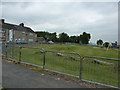
1
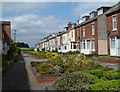
Bentinck Road towards Woodthorpe Road
Two lines of terraced houses with a wide road between now planted with a series of square raised beds.
Image: © Andrew Hill
Taken: 2 Jun 2011
0.01 miles
2
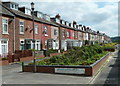
Bentinck Road terrace
The northern terrace from the Woodthorpe Lane end. With each terrace have service roads on the far side, the wide central avenue was planted with a series of square raised beds in a project dating from 2004.
Image: © Andrew Hill
Taken: 2 Jun 2011
0.01 miles
3
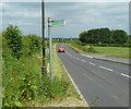
Woodthorpe Road north of Shuttlewood
The B6419 passing the houses at Bentinck Road just off to the right.
Image: © Andrew Hill
Taken: 2 Jun 2011
0.08 miles
4
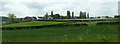
View to Shuttlewood from the north
Looking across fields to the village development along the roads from the junction at the apex which is on the gridline.
Image: © Andrew Hill
Taken: 2 Jun 2011
0.20 miles
5
Playground near crossroads
In the centre of the village, opposite the school.
Image: © Peter Barr
Taken: 29 May 2012
0.24 miles