IMAGES TAKEN NEAR TO
New Bolsover, CHESTERFIELD, S44 6QA
Introduction
This page details the photographs taken nearby to New Bolsover, S44 6QA by members of the Geograph project.
The Geograph project started in 2005 with the aim of publishing, organising and preserving representative images for every square kilometre of Great Britain, Ireland and the Isle of Man.

There are currently over 7.5m images from over14,400 individuals and you can help contribute to the project by visiting https://www.geograph.org.uk
Image Map
Images are licensed for reuse under creativecommons.org/licenses/by-sa/2.0
Notes
- Clicking on the map will re-center to the selected point.
- The higher the marker number, the further away the image location is from the centre of the postcode.
Image Listing (76 Images Found)
Images are licensed for reuse under creativecommons.org/licenses/by-sa/2.0
Image
Details
Distance
1
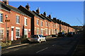
Villas Road, New Bolsover
Part of a model village built for colliery workers during the 1890's.
Image: © Andrew Hill
Taken: 29 Oct 2010
0.00 miles
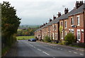
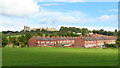
2
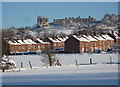
New Bolsover and the castle beyond
Looking to one of the terraces of colliery houses in the model village at New Bolsover. The extensive castle at the top of the hill dominates the view.
Image: © Andrew Hill
Taken: 29 Oct 2010
0.01 miles
3
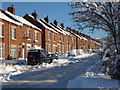
Villas Road, New Bolsover
Looking up the street from the bottom corner in snowy conditions.
Image: © Andrew Hill
Taken: 3 Dec 2010
0.02 miles
4
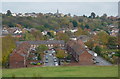
New Bolsover from reserve viewpoint
A view of part of the model village built for colliery workers with Bolsover rising beyond. The viewpoint is the eastern end of an old railway embankment now forming part of the Peter Fidler Reserve.
Image: © Andrew Hill
Taken: 29 Oct 2010
0.03 miles
5
Villas Road
Part of the New Bolsover Model Village, built in the 1890s to house workers of Bolsover Colliery. It is considered to be one of the finest examples of colliery village planning in the country.
Image: © Graham Hogg
Taken: 17 Dec 2013
0.03 miles
6
New Bolsover and the castle in winter
A snowy view of the houses and the hillside to the castle.
Image: © Andrew Hill
Taken: 3 Dec 2010
0.04 miles
7
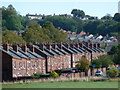
Houses, New Bolsover model village
A terrace of miner's houses at the foot of the hill with Castle Lane rising beyond and houses near the centre of town at the top of the hill. The castle is off to the left.
Image: © Andrew Hill
Taken: 15 Sep 2011
0.04 miles
8
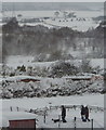
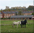
Snowy view of the Doe Lea Valley
In the foreground the people are walking in the park at Carr Vale. The highest in the line of dark trees on the left (just below the pylon) is on the embankment clearly shown on the map running into the next square.
Image: © Andrew Hill
Taken: 2 Dec 2010
0.05 miles
9
New Bolsover Model Village & Bolsover Castle
New Bolsover was built as a model village, built to house workers employed at the Bolsover Colliery. Building commenced in 1891 and two hundred dwellings were built as a double horseshoe around a village green. No expense was spared with even the modest houses having some intricate decoration insomuch that the site is now Grade II listed. The village had a school and a Cooperative store. On the edge of the village were allotments, pig sties and the village cricket pitch but the village had no public houses. There was an institute that would serve workers no more than three glasses of beer a day. The colliery company employed a policeman and anti-social behaviour could result in fines or dismissal. A tramway was built around the site to transport the workers to the mine.
Image: © Colin Park
Taken: 1 Oct 2020
0.05 miles
10
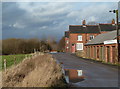
New Bolsover
Towards the southwest corner of the model village, where the road turns sharply by the corner house. A row of garages on the right with fields towards the nature reserves in the floor of the Doe Lea valley to the left.
Image: © Andrew Hill
Taken: 26 Jan 2012
0.06 miles