IMAGES TAKEN NEAR TO
Carr Vale Road, CHESTERFIELD, S44 6PX
Introduction
This page details the photographs taken nearby to Carr Vale Road, S44 6PX by members of the Geograph project.
The Geograph project started in 2005 with the aim of publishing, organising and preserving representative images for every square kilometre of Great Britain, Ireland and the Isle of Man.

There are currently over 7.5m images from over14,400 individuals and you can help contribute to the project by visiting https://www.geograph.org.uk
Image Map
Images are licensed for reuse under creativecommons.org/licenses/by-sa/2.0
Notes
- Clicking on the map will re-center to the selected point.
- The higher the marker number, the further away the image location is from the centre of the postcode.
Image Listing (66 Images Found)
Images are licensed for reuse under creativecommons.org/licenses/by-sa/2.0
Image
Details
Distance
1

Autumn colours, Carr Vale Road
The last of the autumn leaves on a bright morning.
Image: © Andrew Hill
Taken: 7 Nov 2010
0.03 miles
2
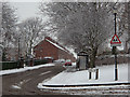
Chapel Road, Carr Vale
The road passes the park on the left, heading towards the model village of New Bolsover.
Image: © Andrew Hill
Taken: 14 Jan 2013
0.04 miles
3
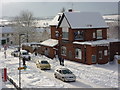
Carr Vale Road and the social club
An upstairs window view of the road and the New Bolsover Social Club in snowy conditions. My footprints in the front garden were 17 inches deep. Generally there was an even covering of about a foot.
Image: © Andrew Hill
Taken: 1 Dec 2010
0.05 miles
4
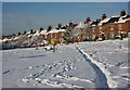
Recreation ground under snow
The park in Carr Vale, New Bolsover, under more than a foot of snow. Looking to houses on Villas Road that from part of the model village built for mine workers.
Image: © Andrew Hill
Taken: 3 Dec 2010
0.05 miles
5
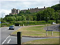
Looking up Carr Vale Road towards Bolsover Castle
The road climbs the hillside towards the main part of the town which is to the right of the castle at the top.
Image: © Andrew Hill
Taken: 3 Jul 2010
0.06 miles
6
Bolsover South Station (converted)
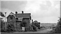
View eastwards, towards Langwith Junction and Lincoln; ex-GC (LD&EC) Lincoln - Tuxford - Langwith - Chesterfield Market Place line. Station closed 3/12/51. The line from Markham Junction through Bolsover South, Bolsover Tunnel and Scarcliffe to the road bridge 300 yards east of Shirebrook North was lifted within three weeks because of the state of Bolsover Tunnel and Carr Vale Viaduct. Chesterfield Market Place and Arkwright Town stations remained open to goods traffic until 4/3/57 whereafter the stretch from Chesterfield MP to Deepsick Lane, Arkwright was lifted. Date of Markham Junction to Longcourse Lane, Duckmanton closure not known. Longcourse Lane to Deepsick Lane remained open for many years to serve Arkwright Colliery via Duckmanton North and East Junctions. Eventually this was rationalised by relaying track from Duckmanton North Junction south along the GC main line trackbed to a new connection straight into Arkwright Colliery, which promptly gave notice of closure!
The photo shows the Bolsover South Station Master's house as a private dwelling in 1963. The station building itself was behind the bush on the extreme right of the photo.
The architecture of the building shown is very much of a family with "Railway Cottages" on the main A632 half way between the bottom of Bolsover Hill and Markham Lane End, with the house immediately next to Clowne South station site (near Wilkinsons in the middle of Clowne) and with several buildings in Langwith Junction and Scarcliffe, some of which were never railway property but were built at the same time as the LDECR in the late 1890s. I'm sure there are others remaining along the route.
Image: © Ben Brooksbank
Taken: 13 Jul 1963
0.07 miles
7
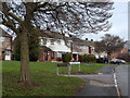
Bainbridge Road, Boslover
A residential street, looking up the hill.
Image: © Andrew Hill
Taken: 2 Jan 2013
0.07 miles
8
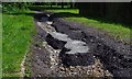
Storm damage to footpath
Two intense storms in the past few weeks have wrought havoc with this local footpath, one of the ways to the nature reserves. Water poured down Carr Vale Road like a river, and some of it diverted down this path tearing up the surface and leaving a channel 6 to 8 inches deep. Further down (behind the camera) an old brick laid surface has been revealed, and even some of those have been torn up by the force of the water.
Image: © Andrew Hill
Taken: 9 Aug 2014
0.07 miles
9
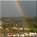
Bolsover hillside and rainbow
A view from our back window. In the foreground is part of a building site for a new housing development in Carr Vale. A bright rainbow shines in front of the rising hillside.
Image: © Andrew Hill
Taken: 3 Apr 2011
0.08 miles
10
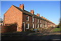
New Bolsover Model Village
The village was built in the 1890s to house workers of Bolsover Colliery. It is considered to be one of the finest examples of colliery village planning in the country.
Image: © Graham Hogg
Taken: 17 Dec 2013
0.09 miles