Bolsover South Station (converted)
Introduction
The photograph on this page of Bolsover South Station (converted) by Ben Brooksbank as part of the Geograph project.
The Geograph project started in 2005 with the aim of publishing, organising and preserving representative images for every square kilometre of Great Britain, Ireland and the Isle of Man.

There are currently over 7.5m images from over 14,400 individuals and you can help contribute to the project by visiting https://www.geograph.org.uk
Bolsover South Station (converted)
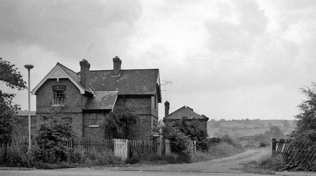
Image: © Ben Brooksbank Taken: 13 Jul 1963
View eastwards, towards Langwith Junction and Lincoln; ex-GC (LD&EC) Lincoln - Tuxford - Langwith - Chesterfield Market Place line. Station closed 3/12/51. The line from Markham Junction through Bolsover South, Bolsover Tunnel and Scarcliffe to the road bridge 300 yards east of Shirebrook North was lifted within three weeks because of the state of Bolsover Tunnel and Carr Vale Viaduct. Chesterfield Market Place and Arkwright Town stations remained open to goods traffic until 4/3/57 whereafter the stretch from Chesterfield MP to Deepsick Lane, Arkwright was lifted. Date of Markham Junction to Longcourse Lane, Duckmanton closure not known. Longcourse Lane to Deepsick Lane remained open for many years to serve Arkwright Colliery via Duckmanton North and East Junctions. Eventually this was rationalised by relaying track from Duckmanton North Junction south along the GC main line trackbed to a new connection straight into Arkwright Colliery, which promptly gave notice of closure! The photo shows the Bolsover South Station Master's house as a private dwelling in 1963. The station building itself was behind the bush on the extreme right of the photo. The architecture of the building shown is very much of a family with "Railway Cottages" on the main A632 half way between the bottom of Bolsover Hill and Markham Lane End, with the house immediately next to Clowne South station site (near Wilkinsons in the middle of Clowne) and with several buildings in Langwith Junction and Scarcliffe, some of which were never railway property but were built at the same time as the LDECR in the late 1890s. I'm sure there are others remaining along the route.
Images are licensed for reuse under creativecommons.org/licenses/by-sa/2.0
Image Location
Latitude
53.22518
Longitude
-1.30181