IMAGES TAKEN NEAR TO
North View Street, CHESTERFIELD, S44 6JE
Introduction
This page details the photographs taken nearby to North View Street, S44 6JE by members of the Geograph project.
The Geograph project started in 2005 with the aim of publishing, organising and preserving representative images for every square kilometre of Great Britain, Ireland and the Isle of Man.

There are currently over 7.5m images from over14,400 individuals and you can help contribute to the project by visiting https://www.geograph.org.uk
Image Map
Images are licensed for reuse under creativecommons.org/licenses/by-sa/2.0
Notes
- Clicking on the map will re-center to the selected point.
- The higher the marker number, the further away the image location is from the centre of the postcode.
Image Listing (57 Images Found)
Images are licensed for reuse under creativecommons.org/licenses/by-sa/2.0
Image
Details
Distance
1
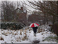
Snowy footpath
Path from the reserves to Carr Vale.
Image: © Andrew Hill
Taken: 14 Jan 2013
0.05 miles
2
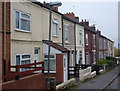
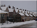
North View Street, Carr Vale
A row of traditional terraced houses.
Image: © Andrew Hill
Taken: 31 Oct 2010
0.05 miles
3
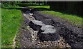
Storm damage to footpath
Two intense storms in the past few weeks have wrought havoc with this local footpath, one of the ways to the nature reserves. Water poured down Carr Vale Road like a river, and some of it diverted down this path tearing up the surface and leaving a channel 6 to 8 inches deep. Further down (behind the camera) an old brick laid surface has been revealed, and even some of those have been torn up by the force of the water.
Image: © Andrew Hill
Taken: 9 Aug 2014
0.07 miles
4
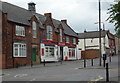
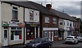
Shop at Carr Vale
There is a "One Stop" general store. There are also some fast food outlets, a hairdresser and a couple of other businesses, as well as the all too familiar sight of closed down business premises.
Image: © Andrew Hill
Taken: 16 May 2011
0.07 miles
5
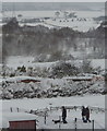
Snowy view of the Doe Lea Valley
In the foreground the people are walking in the park at Carr Vale. The highest in the line of dark trees on the left (just below the pylon) is on the embankment clearly shown on the map running into the next square.
Image: © Andrew Hill
Taken: 2 Dec 2010
0.08 miles
6

Charlesworth Street and Dotti Deli
The terrace of Charlesworth Street can be seen with the delicatessen store on the corner of the Main Street, Carr Vale.
Image: © Andrew Hill
Taken: 17 May 2011
0.08 miles
7
Main Street, Carr Vale
A couple of take-away shops and other businesses as well as houses and unoccupied properties. A cross grid-line shot.
Image: © Andrew Hill
Taken: 16 Aug 2014
0.08 miles
8
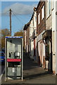
Main Street, Carr Vale
Telephone box and path on the east side of the street.
Image: © Andrew Hill
Taken: 30 Oct 2011
0.08 miles
9
Bathurst Road under snow
One of the streets down in Carr vale at the edge of Boslover.
Image: © Andrew Hill
Taken: 19 Jan 2013
0.08 miles
10
Carr Vale Road and the social club
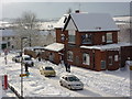
An upstairs window view of the road and the New Bolsover Social Club in snowy conditions. My footprints in the front garden were 17 inches deep. Generally there was an even covering of about a foot.
Image: © Andrew Hill
Taken: 1 Dec 2010
0.09 miles