IMAGES TAKEN NEAR TO
Limekiln Fields Close, CHESTERFIELD, S44 6GW
Introduction
This page details the photographs taken nearby to Limekiln Fields Close, S44 6GW by members of the Geograph project.
The Geograph project started in 2005 with the aim of publishing, organising and preserving representative images for every square kilometre of Great Britain, Ireland and the Isle of Man.

There are currently over 7.5m images from over14,400 individuals and you can help contribute to the project by visiting https://www.geograph.org.uk
Image Map
Images are licensed for reuse under creativecommons.org/licenses/by-sa/2.0
Notes
- Clicking on the map will re-center to the selected point.
- The higher the marker number, the further away the image location is from the centre of the postcode.
Image Listing (139 Images Found)
Images are licensed for reuse under creativecommons.org/licenses/by-sa/2.0
Image
Details
Distance
1
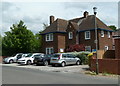
Bolsover police station
The station is on Limekiln Fields Road, set back a bit from the centre of town.
Image: © Andrew Hill
Taken: 6 Jun 2011
0.02 miles
2
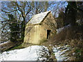
Bolsover Cundy House
The Cundy House is a small conduit house built in the seventeenth century to provide a water supply to Bolsover Castle.
Image: © Gordon Elliott
Taken: 7 Feb 2009
0.10 miles
3
The Cundy House
An early 17th century building that was used to supply water to nearby Bolsover Castle. 'Cundy' is a corruption of the French word 'conduit', or water pipe. The building housed a water tank with a pipe leading to the castle.
Image: © Graham Hogg
Taken: 17 Dec 2013
0.10 miles
4
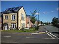
Bolsover - Replacements for the old 'Pre-Fabs'
These are the new properties built to replace the old 'Pre-Fabs' shown at Image
Image: © Gordon Elliott
Taken: 31 Aug 2014
0.11 miles
5
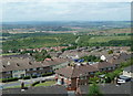
Overlooking Bolsover from Hilltop Road
The northern hillside castle estate stretches across the hillside with former heavy industrial areas in the Doe Lea valley beyond.
Image: © Andrew Hill
Taken: 6 Jun 2011
0.12 miles
6
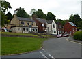
Bolsover Hill and The Fidler's Rest
Looking from the end of Houfton Road. The pub is named after Peter Fidler, a local man who became chief surveyor and mapmaker for the Hudson Bay Company in pioneering days in Canada.
Image: © Andrew Hill
Taken: 16 May 2011
0.12 miles
7
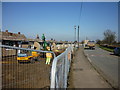
Bolsover - Doomed 'pre-fabs' on Oxcroft Lane
A line of 'pre-fabs' rapidly approaching their final moments. The workmen are in the process of clearing the front gardens prior to demolition of the properties themselves. They have survived for at least 60 years to my knowledge, as I used to pass them on my way to primary school, and are thus well beyond the 'sell-by' date for such 'temporary' housing.
Image: © Gordon Elliott
Taken: 7 Mar 2011
0.13 miles
8
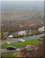
View from Hilltop Avenue
The B6419 runs along the edge of the west facing slope with good views. The two roads in the foreground (in square) are Cundy Road and Houfton Road.
Image: © Andrew Hill
Taken: 18 Nov 2010
0.14 miles
9
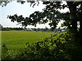
Wheatfield and allotments on Oxcroft Lane, Bolsover
In fields know as Limekiln Field.
Image: © Peter Barr
Taken: 26 Jun 2010
0.14 miles
10
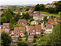
View of Bolsover from the Castle
A view from the Pillar Parlour in the Little Castle.
Image: © David Dixon
Taken: 18 Sep 2017
0.15 miles