IMAGES TAKEN NEAR TO
Shire Lane, CHESTERFIELD, S44 5SH
Introduction
This page details the photographs taken nearby to Shire Lane, S44 5SH by members of the Geograph project.
The Geograph project started in 2005 with the aim of publishing, organising and preserving representative images for every square kilometre of Great Britain, Ireland and the Isle of Man.

There are currently over 7.5m images from over14,400 individuals and you can help contribute to the project by visiting https://www.geograph.org.uk
Image Map
Images are licensed for reuse under creativecommons.org/licenses/by-sa/2.0
Notes
- Clicking on the map will re-center to the selected point.
- The higher the marker number, the further away the image location is from the centre of the postcode.
Image Listing (8 Images Found)
Images are licensed for reuse under creativecommons.org/licenses/by-sa/2.0
Image
Details
Distance
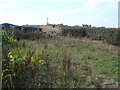
1
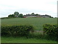
Field rising to High House Farm
View from Shire Lane between Heath and Sutton Scarsdale.
Image: © Andrew Hill
Taken: 6 Jun 2011
0.17 miles
2

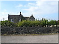
Black Sheep in the Middle - (Owlcotes in the background)
Image: © Alan Heardman
Taken: 20 Feb 2007
0.19 miles
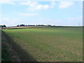
3
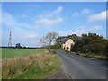
Shire Lane
Approaching Sutton Scarsdale from the direction of Heath.
Image: © Alan Heardman
Taken: 15 Oct 2007
0.20 miles
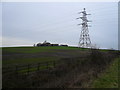
7
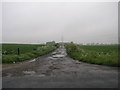
Wet Farm Track
The water on this farm track was caused by Bank Holiday Weekend rain.
Image: © Michael Patterson
Taken: 26 May 2006
0.23 miles