IMAGES TAKEN NEAR TO
Heath, CHESTERFIELD, S44 5RW
Introduction
This page details the photographs taken nearby to S44 5RW by members of the Geograph project.
The Geograph project started in 2005 with the aim of publishing, organising and preserving representative images for every square kilometre of Great Britain, Ireland and the Isle of Man.

There are currently over 7.5m images from over14,400 individuals and you can help contribute to the project by visiting https://www.geograph.org.uk
Image Map
Images are licensed for reuse under creativecommons.org/licenses/by-sa/2.0
Notes
- Clicking on the map will re-center to the selected point.
- The higher the marker number, the further away the image location is from the centre of the postcode.
Image Listing (93 Images Found)
Images are licensed for reuse under creativecommons.org/licenses/by-sa/2.0
Image
Details
Distance
1
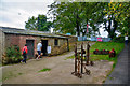
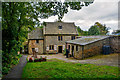
Bolsover District : Stainsby Mill
A mill on this site appears to have existed from the early 13th century. Originally all the water for the mill came from the River Doe Lea which fed the Miller's Pond on the Hardwick estate. By 1762 the Stainsby Pond, fed by the Stainsby Brook, had been constructed and the water also fed into the Mill Pond which was situated the other side of the road from the mill. Water was allowed into the mill race by sluice gates under the road.
Image: © Lewis Clarke
Taken: 3 Oct 2018
0.01 miles
2
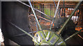
Bolsover District : Stainsby Mill
A 17 ft (5.2 m) diameter breast shot water wheel installed between 1846 and 1850.
Image: © Lewis Clarke
Taken: 3 Oct 2018
0.01 miles
3
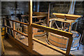
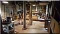
Bolsover District : Stainsby Mill
The curious cogs and machinery of a fully operational watermill.
Image: © Lewis Clarke
Taken: 3 Oct 2018
0.02 miles
4
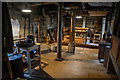
Bolsover District : Stainsby Mill
Situated on the Hardwick estate, the mill offers an evocation of the workplace of a 19th-century miller.
Image: © Lewis Clarke
Taken: 3 Oct 2018
0.02 miles
5
Bolsover District : Stainsby Mill
As a result of the death of the 10th Duke of Devonshire in 1950, as part of the Hardwick Estate, the mill was passed to the government in lieu of death duties. It was given to the National Trust who carried out a partial restoration in 1976. As a result of a report on the mill's future by the Ault Hucknall Environment Group in 1990 a full restoration to working order was commenced in 1991 with the mill being opened to the public again in 1992.
Image: © Lewis Clarke
Taken: 3 Oct 2018
0.02 miles
6
Bolsover District : Stainsby Mill
The mill, which has been restored to full working order, is a Grade II listed building and is under the ownership of the National Trust.
Image: © Lewis Clarke
Taken: 3 Oct 2018
0.02 miles
7
Bolsover : Stainsby Mill
Situated on the Hardwick estate, the mill offers a vivid evocation of the workplace of a 19th-century miller.
Image: © Lewis Clarke
Taken: 3 Oct 2018
0.02 miles
8
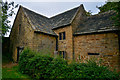
Stainsby Mill, Ault Hucknall
Late 18th century disused water mill, now managed by the National Trust. It is a Grade II listed building (Historic England List Entry Number: 1052316 http://www.heritagegateway.org.uk/Gateway/Results_Single.aspx?uid=1052316&resourceID=5 Historic England).
Image: © David Dixon
Taken: 7 Sep 2016
0.02 miles
9
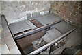
Stainsby Mill - kiln
The incomplete perforated tile drying floor with the coal fired furnace below. This was used for drying the grain, especially oats, before milling or hulling.
Image: © Chris Allen
Taken: 16 Feb 2013
0.02 miles
10
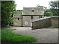
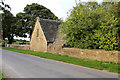
Ault Hucknall: Stainsby Mill
This late 18th century flour mill is now a National Trust property. It is a Grade II Listed Building of coursed sandstone and ashlar with a stone slate roof.
Image: © Nigel Cox
Taken: 30 Aug 2010
0.02 miles