IMAGES TAKEN NEAR TO
Rectory Road, CHESTERFIELD, S44 5JH
Introduction
This page details the photographs taken nearby to Rectory Road, S44 5JH by members of the Geograph project.
The Geograph project started in 2005 with the aim of publishing, organising and preserving representative images for every square kilometre of Great Britain, Ireland and the Isle of Man.

There are currently over 7.5m images from over14,400 individuals and you can help contribute to the project by visiting https://www.geograph.org.uk
Image Map
Images are licensed for reuse under creativecommons.org/licenses/by-sa/2.0
Notes
- Clicking on the map will re-center to the selected point.
- The higher the marker number, the further away the image location is from the centre of the postcode.
Image Listing (16 Images Found)
Images are licensed for reuse under creativecommons.org/licenses/by-sa/2.0
Image
Details
Distance
1
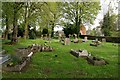
St Peter & St Paul's Church graveyard
In the village of Duckmanton
Image: © Graham Hogg
Taken: 28 Apr 2014
0.04 miles
2
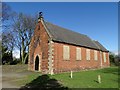
St Peter and St Paul's Church, Long Duckmanton
The boarded windows and the lead-stripped roof are evidence that this Anglican church no longer functions as it once did - serving the communities of Duckmanton and Long Duckmanton.
Image: © Neil Theasby
Taken: 21 Mar 2014
0.05 miles
3
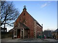
Former church of St Peter and St Paul, Long Duckmanton
Now a dwelling.
Image: © Jonathan Thacker
Taken: 24 Feb 2023
0.05 miles
4
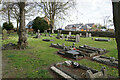
Churchyard of St Peter & St Paul, Duckmanton
The church building is behind but has now been closed as a place of worship.
Image: © Bill Boaden
Taken: 18 Apr 2022
0.05 miles
5
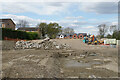
New housing development site in Long Duckmanton
Houses are appearing at the far end, near to St Peter & St Paul's Church.
Image: © Bill Boaden
Taken: 18 Apr 2022
0.07 miles
6
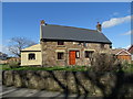
An old house in Long Duckmanton
The main structure of this house is thought to be over three hundred years old but additions to the side and rear were made in the nineteenth century. It sits in a prominent position overlooking the A632.
Image: © Neil Theasby
Taken: 21 Mar 2014
0.09 miles
7
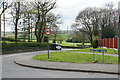
The southern end of Rectory Road
Here it meets the A632. Beyond, there are green fields between Bolsover and Chesterfield.
Image: © Bill Boaden
Taken: 18 Apr 2022
0.09 miles
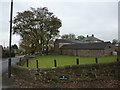
8
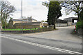
Hilltop Farm
Living up to its name, the farm sits on the top of the Duckmanton ridge.
Image: © Bill Boaden
Taken: 18 Apr 2022
0.12 miles
9
Hilltop Farm, Long Duckmanton
On the A632 from Chesterfield to Bolsover.
Image: © Peter Barr
Taken: 29 Oct 2010
0.14 miles
10
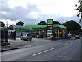
Service station on Chesterfield Road (A632)
Image: © JThomas
Taken: 7 Sep 2013
0.15 miles