IMAGES TAKEN NEAR TO
Traversgate, CHESTERFIELD, S44 5FH
Introduction
This page details the photographs taken nearby to Traversgate, S44 5FH by members of the Geograph project.
The Geograph project started in 2005 with the aim of publishing, organising and preserving representative images for every square kilometre of Great Britain, Ireland and the Isle of Man.

There are currently over 7.5m images from over14,400 individuals and you can help contribute to the project by visiting https://www.geograph.org.uk
Image Map
Images are licensed for reuse under creativecommons.org/licenses/by-sa/2.0
Notes
- Clicking on the map will re-center to the selected point.
- The higher the marker number, the further away the image location is from the centre of the postcode.
Image Listing (17 Images Found)
Images are licensed for reuse under creativecommons.org/licenses/by-sa/2.0
Image
Details
Distance
1
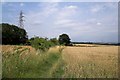
Fields North of A632
These corn fields appear after following the public footpath north west out of the White Hart car park.
Image: © Stephen G Taylor
Taken: 26 Jul 2006
0.05 miles
2
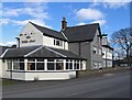
Calow - The White Hart
On Top Road. For an alternative view, please see Image
Image: © Dave Bevis
Taken: 25 Feb 2016
0.08 miles
3
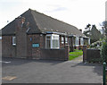
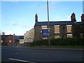
Calow - The Little Homes
Nos 190 to 196 Top Road. This set of 4 one-bedroom bungalows was built in 1932 and renovated in 1993. The bungalows are maintained by an almshouses charity, Harry Wilde Memorial Homes. See http://www.housingcare.org/downloads/facilities/generated-brochures/83699-harry-wilde-memorial-homes-calow-england.pdf for more details.
Image: © Dave Bevis
Taken: 25 Feb 2016
0.08 miles
4

The White Hart in Calow
Walking the Chesterfield Round.
Image: © steven ruffles
Taken: 19 Apr 2013
0.08 miles
5
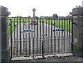
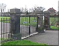
Calow - Eastwood Park gates - from north
For more information about the war memorial beyond the gates, please see http://www.warmemorials.org/search-grants/?gID=463 .
Image: © Dave Bevis
Taken: 25 Feb 2016
0.09 miles
7
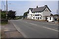
The White Hart, Calow
The White Hart marks the eastern edge of the village of Calow. The A632 to Chesterfield runs through the picture.
Image: © Stephen G Taylor
Taken: 26 Jul 2006
0.10 miles
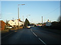
10
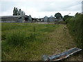
Lodge Farm, near Calow
One of two farms of the same name at this spot.
Image: © Peter Barr
Taken: 7 Jul 2010
0.17 miles