IMAGES TAKEN NEAR TO
Creswell Road, CHESTERFIELD, S43 4PN
Introduction
This page details the photographs taken nearby to Creswell Road, S43 4PN by members of the Geograph project.
The Geograph project started in 2005 with the aim of publishing, organising and preserving representative images for every square kilometre of Great Britain, Ireland and the Isle of Man.

There are currently over 7.5m images from over14,400 individuals and you can help contribute to the project by visiting https://www.geograph.org.uk
Image Map
Images are licensed for reuse under creativecommons.org/licenses/by-sa/2.0
Notes
- Clicking on the map will re-center to the selected point.
- The higher the marker number, the further away the image location is from the centre of the postcode.
Image Listing (29 Images Found)
Images are licensed for reuse under creativecommons.org/licenses/by-sa/2.0
Image
Details
Distance
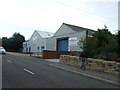
2
New build houses, open weekend
On Cresswell Road.
Image: © Peter Barr
Taken: 28 Jul 2012
0.03 miles
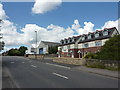
3
North Road, Clowne
Heading towards the town centre from the A616 junction.
Image: © Andrew Hill
Taken: 18 Nov 2010
0.09 miles
5
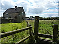
Footpaths near Manor Farm
Harlesthorpe, near the fishery pond.
Image: © Peter Barr
Taken: 28 Jul 2012
0.10 miles
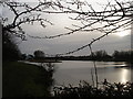
6
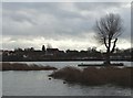
A view of Harlesthorpe Dam
On the little island right of centre, a heron sits conserving energy and passing time.
Image: © Neil Theasby
Taken: 1 Dec 2015
0.11 miles
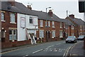
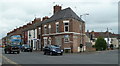
7
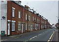
Terraced houses, North Road, Clowne
Looking past the turn for Salvin Crescent to a long terrace.
Image: © Andrew Hill
Taken: 18 Nov 2010
0.13 miles
9
Junction of Barlborough Road and Rotherham Road
The A616 and A618 meet at this junction, with the B6417 coming from the town centre behind the photographer. These busy roads are closely lined with terraced houses.
Image: © Andrew Hill
Taken: 26 May 2011
0.13 miles
10
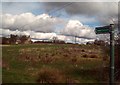
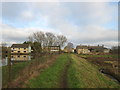
Footpath to Manor Farm
Heathland situated on the north fringe of Clowne and pictured here from Hickinwood Lane. Manor Farm on the left of the picture probably stands on the site of the original manor mentioned in Domesday Book and the path here also leads to Harlesthorpe Dam. Situated out of sight to the left of the farm, this pond was used in the past for separating flax fibres in a process known as 'retting'.
Image: © Jonathan Clitheroe
Taken: 17 Mar 2012
0.13 miles