IMAGES TAKEN NEAR TO
Glenavon Close, CHESTERFIELD, S43 2QG
Introduction
This page details the photographs taken nearby to Glenavon Close, S43 2QG by members of the Geograph project.
The Geograph project started in 2005 with the aim of publishing, organising and preserving representative images for every square kilometre of Great Britain, Ireland and the Isle of Man.

There are currently over 7.5m images from over14,400 individuals and you can help contribute to the project by visiting https://www.geograph.org.uk
Image Map
Images are licensed for reuse under creativecommons.org/licenses/by-sa/2.0
Notes
- Clicking on the map will re-center to the selected point.
- The higher the marker number, the further away the image location is from the centre of the postcode.
Image Listing (24 Images Found)
Images are licensed for reuse under creativecommons.org/licenses/by-sa/2.0
Image
Details
Distance
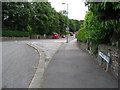
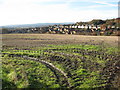
4

Parkgate Lane - View across farmland
Looking in the general direction of Glasshouse Common.
Image: © Alan Heardman
Taken: 18 Nov 2008
0.09 miles
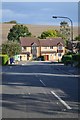
5
New Whittington, Nr Chesterfield
Looking north towards Eckington.
Image: © Andrew Loughran
Taken: 14 Feb 2006
0.09 miles
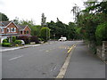
6
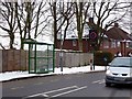
Bus shelter and speed warning sign
On Handley Road, Glasshouse Common
Image: © Graham Hogg
Taken: 23 Jan 2013
0.09 miles
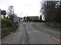
7
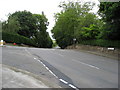
New Whittington - Handley Road and Eckington Road
Image: © Alan Heardman
Taken: 27 Jun 2008
0.10 miles

9
Parkgate Lane - View across farmland
Houses at New Whittington can be seen in the distance.
Image: © Alan Heardman
Taken: 18 Nov 2008
0.11 miles
10
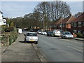
Handley Road (B6052), New Whittington
Heading north.
Image: © JThomas
Taken: 7 Mar 2015
0.12 miles