IMAGES TAKEN NEAR TO
Chestnut Drive, CHESTERFIELD, S43 2LZ
Introduction
This page details the photographs taken nearby to Chestnut Drive, S43 2LZ by members of the Geograph project.
The Geograph project started in 2005 with the aim of publishing, organising and preserving representative images for every square kilometre of Great Britain, Ireland and the Isle of Man.

There are currently over 7.5m images from over14,400 individuals and you can help contribute to the project by visiting https://www.geograph.org.uk
Image Map
Images are licensed for reuse under creativecommons.org/licenses/by-sa/2.0
Notes
- Clicking on the map will re-center to the selected point.
- The higher the marker number, the further away the image location is from the centre of the postcode.
Image Listing (7 Images Found)
Images are licensed for reuse under creativecommons.org/licenses/by-sa/2.0
Image
Details
Distance
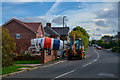
1
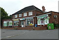
Shops in Hollingwood
A mini parade of shops with food & off licence, two fast food and another. At the end of Hollingwood Crescent.
Image: © Andrew Hill
Taken: 10 Jun 2011
0.12 miles
2
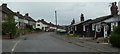
Hollingwood Crescent
The street has traditional council houses on one side and a line of surviving prefabricated bungalows on the other. Looking across the end of Birch Lane on the left.
Image: © Andrew Hill
Taken: 10 Jun 2011
0.13 miles
3
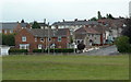
Recreation ground and houses, Hollingwood
The edge of a recreation ground with football pitches, looking to houses at the corner of Station Road and Beech Street.
Image: © Andrew Hill
Taken: 10 Jun 2011
0.19 miles
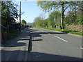
4
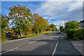
Brimington : Troughbrook Road
Looking along Troughbrook Road.
Image: © Lewis Clarke
Taken: 2 Oct 2018
0.20 miles
5
Brimington : Troughbrook Road
A residential road in Brimington.
Image: © Lewis Clarke
Taken: 2 Oct 2018
0.20 miles
6
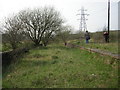
Staveley Works Station
All that's left of Staveley Works Station on the Chesterfield Loop of the Great Central Railway's London Extension. The Chesterfield Canal ran underneath.
Image: © Gareth Foster
Taken: 2 Apr 2005
0.20 miles