IMAGES TAKEN NEAR TO
Wheeldon Crescent, CHESTERFIELD, S43 1AW
Introduction
This page details the photographs taken nearby to Wheeldon Crescent, S43 1AW by members of the Geograph project.
The Geograph project started in 2005 with the aim of publishing, organising and preserving representative images for every square kilometre of Great Britain, Ireland and the Isle of Man.

There are currently over 7.5m images from over14,400 individuals and you can help contribute to the project by visiting https://www.geograph.org.uk
Image Map (Loading...)


Getting Data...Please wait
Leaflet Map data © OpenStreetMap
Images are licensed for reuse under creativecommons.org/licenses/by-sa/2.0
Notes
- Clicking on the map will re-center to the selected point.
- The higher the marker number, the further away the image location is from the centre of the postcode.
Image Listing (9 Images Found)
Images are licensed for reuse under creativecommons.org/licenses/by-sa/2.0
Image
Details
Distance
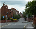
1
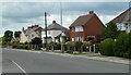
Station Road, Brimington
Houses by the B6050.
Image: © Andrew Hill
Taken: 20 Jun 2011
0.09 miles
2
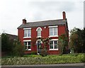
Red house in Brimington
Called "Thornleigh", this attractive house had yellow roses climbing round the front doorway.
Image: © Neil Theasby
Taken: 28 Apr 2014
0.20 miles
4
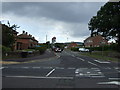
Bus stop on Chesterfield Road, Brimington
Image: © Neil Theasby
Taken: 28 Apr 2014
0.21 miles
5
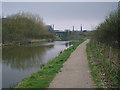
Chesterfield Canal - Dema Glass Chimneys in Background
Image: © Alan Heardman
Taken: 7 Jul 1998
0.22 miles
9
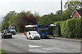
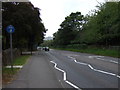
Road junction and narrow street in Brimington
The B6050 turns right, while the houses ahead are on Foljambe Road which is a no through route for vehicles. Brimington is a civil parish within the borough of Chesterfield.
Image: © Andrew Hill
Taken: 20 Jun 2011
0.24 miles