IMAGES TAKEN NEAR TO
Clod Hall Lane, CHESTERFIELD, S42 7DF
Introduction
This page details the photographs taken nearby to Clod Hall Lane, S42 7DF by members of the Geograph project.
The Geograph project started in 2005 with the aim of publishing, organising and preserving representative images for every square kilometre of Great Britain, Ireland and the Isle of Man.

There are currently over 7.5m images from over14,400 individuals and you can help contribute to the project by visiting https://www.geograph.org.uk
Image Map
Images are licensed for reuse under creativecommons.org/licenses/by-sa/2.0
Notes
- Clicking on the map will re-center to the selected point.
- The higher the marker number, the further away the image location is from the centre of the postcode.
Image Listing (8 Images Found)
Images are licensed for reuse under creativecommons.org/licenses/by-sa/2.0
Image
Details
Distance
1
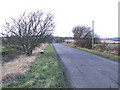
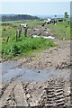
Near Clod Hall Farm.
A north westerly view in the direction of Clod Hall Farm and Blackleach Brook.
Image: © Mike Fowkes
Taken: 14 Feb 2006
0.09 miles
2

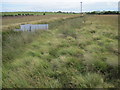
Whibbersley Cross viewed from Clodhall Lane
The stone cross can just be seen above the moorland grasses to the right of centre of the picture.
Image: © Alan Heardman
Taken: 24 Oct 2008
0.11 miles
3
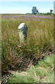
Whibbersley Cross
This cross is nearly lost to view amongst the rushes in this wasteland near Clod Hall Farm. The Cross is to the east of the nearby road but somewhat confusingly the Ordnance Survey has the name written to the west of the road.
Image: © Roger Temple
Taken: 23 Aug 2007
0.11 miles
5
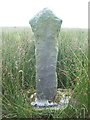
Whibbersley Cross
Cross base and shaft situated on marshy Access Land near Clod Hall Farm. It took me 4 attempts to locate this feature mainly due to poor navigational skills but also because its label is confusingly placed on the opposite side of the road on the OS map (the 1:25,000 map is especially deceptive). The cross is also difficult to pick out from the surrounding landscape as it sits in a sunken area surrounded by reed grass. Thanks to Roger Temple for supplying the grid reference and saving me further trips.
Image: © Jonathan Clitheroe
Taken: 22 Jul 2011
0.12 miles
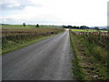
8
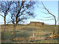
The barn.
Just inside the SK2972 grid square, this barn presents an attractive sight framed by the roadside trees.
Image: © Mike Fowkes
Taken: 14 Feb 2006
0.23 miles