IMAGES TAKEN NEAR TO
Longedge Lane, CHESTERFIELD, S42 6PB
Introduction
This page details the photographs taken nearby to Longedge Lane, S42 6PB by members of the Geograph project.
The Geograph project started in 2005 with the aim of publishing, organising and preserving representative images for every square kilometre of Great Britain, Ireland and the Isle of Man.

There are currently over 7.5m images from over14,400 individuals and you can help contribute to the project by visiting https://www.geograph.org.uk
Image Map
Images are licensed for reuse under creativecommons.org/licenses/by-sa/2.0
Notes
- Clicking on the map will re-center to the selected point.
- The higher the marker number, the further away the image location is from the centre of the postcode.
Image Listing (5 Images Found)
Images are licensed for reuse under creativecommons.org/licenses/by-sa/2.0
Image
Details
Distance
1
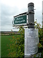
Footpath sign and closure notice
The path was closed, and is due to remain so until late 2012 while extensive works take place. There are no alternative routes, resulting in a large inaccessible area.
Image: © Andrew Hill
Taken: 23 May 2011
0.17 miles
2
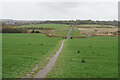
Path down to the River Rother
Some flood alleviation works have been undertaken in the valley.
Image: © Bill Boaden
Taken: 6 Apr 2022
0.22 miles
3
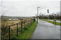
Hornbeam Drive
A new road providing access to The Avenue, a large new housing development on a brown field site, a former coking plant. It is viewed in rain.
Image: © Bill Boaden
Taken: 6 Apr 2022
0.23 miles
5
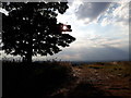
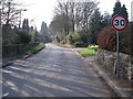
Evening Sunshine
Late evening sunshine back-lighting a tree above a recently cut field of hay.
Image: © Tim Bestwick
Taken: 16 Jul 2018
0.25 miles