IMAGES TAKEN NEAR TO
Wood Street, CHESTERFIELD, S42 5RS
Introduction
This page details the photographs taken nearby to Wood Street, S42 5RS by members of the Geograph project.
The Geograph project started in 2005 with the aim of publishing, organising and preserving representative images for every square kilometre of Great Britain, Ireland and the Isle of Man.

There are currently over 7.5m images from over14,400 individuals and you can help contribute to the project by visiting https://www.geograph.org.uk
Image Map
Images are licensed for reuse under creativecommons.org/licenses/by-sa/2.0
Notes
- Clicking on the map will re-center to the selected point.
- The higher the marker number, the further away the image location is from the centre of the postcode.
Image Listing (30 Images Found)
Images are licensed for reuse under creativecommons.org/licenses/by-sa/2.0
Image
Details
Distance
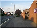
1
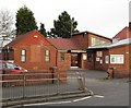
Holmewood - St Albans Centre
An Anglican church and community centre on Heath Road. It is in the same benefice as All Saints Church, Heath.
Image: © Dave Bevis
Taken: 8 Jan 2016
0.11 miles
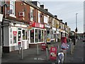
3
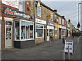
Holmewood - Henstocks Bakers Shop
One of a set of shops located on the north side of Heath Road. Henstocks is a local firm with a retail shop and bakery on Chatsworth Road in Chesterfield and retail shops at West Bars in Chesterfield, High Street in Clay Cross and here in Holmewood.
Image: © Dave Bevis
Taken: 8 Jan 2016
0.11 miles
5
Holmewood - Entrance to Library and Information Centre
Image: © Alan Heardman
Taken: 9 Aug 2007
0.12 miles
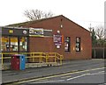
6
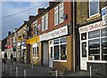
Holmewood - Post Office
On north side of Heath Road.
Image: © Dave Bevis
Taken: 8 Jan 2016
0.13 miles
8
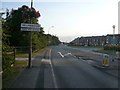
Entering Holmewood from M1 Junction 29 Direction
Image: © Alan Heardman
Taken: 9 Aug 2007
0.14 miles
9
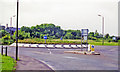
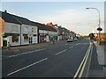
Heath: site of former main-line station
View NW on Hardwick Road at the A6175 roundabout, Heath station having been just the other side of the present roundabout. It was on the Sheffield via Staveley (to right) - (to left) Nottingham section of the ill-fated ex-GCR 'London Extension' main line; also the Chesterfield Loop on this route turned off a mile or so to the north (right), rejoining the through line at Staveley. The station was closed to passengers 4/3/63, when local services ceased (to goods on 12/6/65), but main line services continued until 5/9/66, with final closure on 11/9/67. (Cf. Image]).
Image: © Ben Brooksbank
Taken: 20 Jun 1998
0.14 miles
10
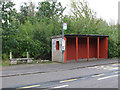
Holmewood - bus shelter at Devonshire Terrace
This spacious bus shelter must be a hangover from the days when it would be crowded with shift-workers from the local heavy industry (colliery, coke ovens and railway sidings) waiting for their bus home. Behind the bus shelter stood Heath railway station (closed 1966). For a photo of the terrace across the road from the bus shelter, please see Image
Image: © Dave Bevis
Taken: 10 Oct 2011
0.14 miles