IMAGES TAKEN NEAR TO
Birkin Lane, CHESTERFIELD, S42 5BW
Introduction
This page details the photographs taken nearby to Birkin Lane, S42 5BW by members of the Geograph project.
The Geograph project started in 2005 with the aim of publishing, organising and preserving representative images for every square kilometre of Great Britain, Ireland and the Isle of Man.

There are currently over 7.5m images from over14,400 individuals and you can help contribute to the project by visiting https://www.geograph.org.uk
Image Map
Images are licensed for reuse under creativecommons.org/licenses/by-sa/2.0
Notes
- Clicking on the map will re-center to the selected point.
- The higher the marker number, the further away the image location is from the centre of the postcode.
Image Listing (37 Images Found)
Images are licensed for reuse under creativecommons.org/licenses/by-sa/2.0
Image
Details
Distance
1
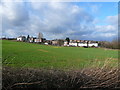
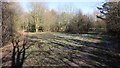
Grassmoor - Birkin Lane from Five Pits Trail
Image: © Alan Heardman
Taken: 20 Jan 2007
0.02 miles
2
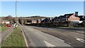
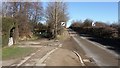
Birkin Lane
A walk around Grassmoor
Image : Previous - (10 of 51) - Next : Image
Looking in a north-easterly direction the photograph shows a new housing development on Birkin Lane. Ahead, the Lane rises to cross a bridge over the Five Pits Trail https://www.derbyshire.gov.uk/images/5%20Pits%20lft%20Jan%202014%20web_tcm44-216030.pdf .
Just beyond the vehicle driving down the lane, on the left, there is an access point to Grassmoor Country Park https://www.derbyshire.gov.uk/images/Grassmoor%20Country%20Park_tcm44-194014.pdf .
Image: © Alan Walker
Taken: 7 Feb 2018
0.02 miles
4
Path junction in Grassmoor Country Park
Reclaimed from the former Grassmoor Colliery, the park lies at the northern end of the Five Pits Trail. The Trail is a network of surfaced tracks for recreational use which mostly follows the route of the Great Central Railway. It connects the former collieries of Grassmoor, Williamthorpe, Holmewood, Pilsley and Tibshelf.
Image: © Graham Hogg
Taken: 29 Apr 2015
0.07 miles
5
Grassmoor Country Park
A walk around Grassmoor
Image : Previous - (8 of 51) - Next : Image
Looking in a north-easterly direction this is the view upon entering Grassmoor Country Park https://www.derbyshire.gov.uk/images/Grassmoor%20Country%20Park_tcm44-194014.pdf from Birkin Lane.
See also this photograph by:- Graham Hogg:- Image
Image: © Alan Walker
Taken: 7 Feb 2018
0.08 miles
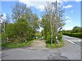
6
Birkin Lane
A walk around Grassmoor
Image : Previous - (9 of 51) - Next : Image
Looking in a north-easterly direction the photograph shows Birkin Lane at a point where the Lane rises to cross a bridge over the Five Pits Trail https://www.derbyshire.gov.uk/images/5%20Pits%20lft%20Jan%202014%20web_tcm44-216030.pdf and, to the left, there is an access point to Grassmoor Country Park https://www.derbyshire.gov.uk/images/Grassmoor%20Country%20Park_tcm44-194014.pdf .
See also this photograph by Chris Morgan:- Image
Image: © Alan Walker
Taken: 7 Feb 2018
0.09 miles
7
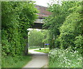
Bridge over the Five Pits Trail
The trail follows a former railway line. The bridge carries Birkin Lane which runs between Grassmoor and Temple Normanton. Grassmoor Country Park opens out beyond the bridge.
Image: © Andrew Hill
Taken: 23 May 2011
0.10 miles
8

Bridge art work
A bridge carrying Birkin Lane, at Grassmoor Country Park, at the start of the Five Pits Trail, has been painted with a mural with themes of mining.
Image: © Peter Barr
Taken: 8 Sep 2010
0.10 miles
9
Grassmoor - Birkin Lane Road Bridge
Viewed from Five Pits Trail. This is the point where the trail enters Grassmoor Country Park.
Image: © Alan Heardman
Taken: 20 Jan 2007
0.11 miles
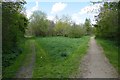
10
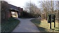
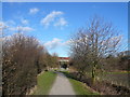
Grassmoor Country Park
A walk around Grassmoor
Image : Previous - (6 of 51) - Next : Image
Looking south-west, this footpath in Grassmoor Country Park https://www.derbyshire.gov.uk/images/Grassmoor%20Country%20Park_tcm44-194014.pdf runs parallel to Birkin Lane and is part of the Five Pits Trail https://www.derbyshire.gov.uk/images/5%20Pits%20lft%20Jan%202014%20web_tcm44-216030.pdf .
The trail goes under the Birkin Lane bridge and leaves the country park at this point on its way south-east, passing Wolfie Pond and toward a crossing with Williamthorpe Road.
The footpath, leading to the right, continues toward an access point at Birkin Lane.
See also this photograph by Alan Heardman:- Image
- - -
An OS map surveyed in 1914 and published in 1921 shows that the Grassmoor Colliery was serviced by two railway companies, The Midland Railway and the Great Central Railway.
The Midland Railway's Bonds Main Colliery Branch line left the main line about 1.5km north-west of here to service another colliery at Temple Normanton. Branching off from that line the company then built the Pilsley Extension line which travelled through Grassmoor Colliery onward to the south of Pilsley before looping back to rejoin the main line at Morton. It is the route of the Midland Railway's Pilsley Extension line that the Five Pits Trail largely follows until it reaches Timber Lane. At this point the Midland Railway and the Great Central Railway branch lines ran adjacent to each other, both servicing Pilsley Colliery, before their routes diverged near the Great Central Railway's Pilsley station.
The Great Central Railway's two access routes into the Grassmoor Colliery came from the north and from the east where ran the company's Chesterfield Loop line. To the north was Grassmoor station on the Chesterfield Loop and from here lines near Corbriggs ran into the colliery site. From the east the Great Central Railway constructed their Grassmoor Colliery Branch line to link with the Chesterfield Loop.
Both companies are represented in this photograph. On the left, under the Birkin Lane bridge were the tracks of the Midland Railway's Pilsley Extension. On the right were sidings associated with the Great Central Railway's Grassmoor Colliery Branch line. Some distance behind the viewpoint was a bridge carrying the GCR line over the MR line. On the ground no evidence of this structure or its associated embankments now exists.
Image: © Alan Walker
Taken: 7 Feb 2018
0.12 miles