IMAGES TAKEN NEAR TO
Coupland Close, CHESTERFIELD, S41 9TB
Introduction
This page details the photographs taken nearby to Coupland Close, S41 9TB by members of the Geograph project.
The Geograph project started in 2005 with the aim of publishing, organising and preserving representative images for every square kilometre of Great Britain, Ireland and the Isle of Man.

There are currently over 7.5m images from over14,400 individuals and you can help contribute to the project by visiting https://www.geograph.org.uk
Image Map
Images are licensed for reuse under creativecommons.org/licenses/by-sa/2.0
Notes
- Clicking on the map will re-center to the selected point.
- The higher the marker number, the further away the image location is from the centre of the postcode.
Image Listing (3 Images Found)
Images are licensed for reuse under creativecommons.org/licenses/by-sa/2.0
Image
Details
Distance
1
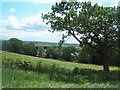
Fields Overlooking New Whittington
This picture was taken from the footpath which skirts the edge of the grid square en route to Grasscroft Wood.
Image: © Jonathan Clitheroe
Taken: 4 Jun 2012
0.06 miles
2
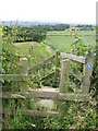
Stile and Footpath View
Having crossed the first field from Grasscroft Wood, the footpath continues towards St.Bartholomews Church, New Whittington.
Image: © Alan Heardman
Taken: 27 Jun 2008
0.12 miles
3
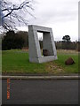
Woodmere Drive, New Whittington, Chesterfield.
Concrete monument at entrance to private estate on Woodmere Drive.
Image: © Andrew Loughran
Taken: 14 Feb 2006
0.16 miles