IMAGES TAKEN NEAR TO
Carrwood Road, CHESTERFIELD, S41 9RH
Introduction
This page details the photographs taken nearby to Carrwood Road, S41 9RH by members of the Geograph project.
The Geograph project started in 2005 with the aim of publishing, organising and preserving representative images for every square kilometre of Great Britain, Ireland and the Isle of Man.

There are currently over 7.5m images from over14,400 individuals and you can help contribute to the project by visiting https://www.geograph.org.uk
Image Map
Images are licensed for reuse under creativecommons.org/licenses/by-sa/2.0
Notes
- Clicking on the map will re-center to the selected point.
- The higher the marker number, the further away the image location is from the centre of the postcode.
Image Listing (13 Images Found)
Images are licensed for reuse under creativecommons.org/licenses/by-sa/2.0
Image
Details
Distance
1
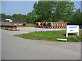
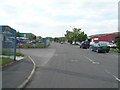
Trading Estate View
Fusion Power Systems cable rolls.
Image: © Alan Heardman
Taken: 11 May 2008
0.05 miles

5
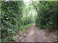
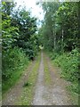
Woodland path
Roughpiece Wood lies next to the Dronfield By-pass, (the A61). It is mixed conifer and native species, mainly oak and silver birch.
Image: © Peter Barr
Taken: 3 Aug 2010
0.15 miles
6
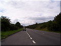
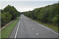
The Unstone - Dronfield by-pass
This is the Sheffield bound carriageway of the A61(T) seen from the lay-by near to Chesterfield Trading Estate.
Image: © Martin Speck
Taken: 7 Aug 2010
0.15 miles
9
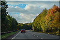
North East Derbyshire : The A61 Unstone Dronfield By-Pass
A road between Chesterfield and Dronfield.
Image: © Lewis Clarke
Taken: 30 Sep 2018
0.21 miles
10
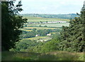
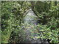
Gap between woods with views
View ESE from a grassy ride between woodland areas. The ground drops steeply to the A61 with views beyond. The Line of terraced houses on the hillside are on Millcross Lane between Barlow and Common Side Image
Image: © Andrew Hill
Taken: 14 Jun 2011
0.21 miles