IMAGES TAKEN NEAR TO
Red Lane, CHESTERFIELD, S41 9QU
Introduction
This page details the photographs taken nearby to Red Lane, S41 9QU by members of the Geograph project.
The Geograph project started in 2005 with the aim of publishing, organising and preserving representative images for every square kilometre of Great Britain, Ireland and the Isle of Man.

There are currently over 7.5m images from over14,400 individuals and you can help contribute to the project by visiting https://www.geograph.org.uk
Image Map
Images are licensed for reuse under creativecommons.org/licenses/by-sa/2.0
Notes
- Clicking on the map will re-center to the selected point.
- The higher the marker number, the further away the image location is from the centre of the postcode.
Image Listing (26 Images Found)
Images are licensed for reuse under creativecommons.org/licenses/by-sa/2.0
Image
Details
Distance
1
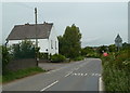
Building by Station Lane
A low lying road in the Rother valley by the entrance to extensive sewage and waste water treatment works.
Image: © Andrew Hill
Taken: 10 Jun 2011
0.07 miles
3
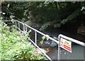
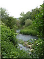
River Rother near Station Lane Sewage Works
Image: © Neil Theasby
Taken: 30 Jul 2014
0.12 miles
5
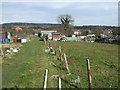
Allotments, Old Whittington
Off Station Lane.
Image: © JThomas
Taken: 7 Mar 2015
0.13 miles
6
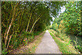
Chesterfield : Chesterfield Canal
The Chesterfield Canal is a narrow canal in the East Midlands of England and it is known locally as 'Cuckoo Dyke'.
Image: © Lewis Clarke
Taken: 2 Oct 2018
0.16 miles
7
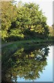
Tree with reflection - Chesterfield Canal
Image: © Neil Theasby
Taken: 12 Oct 2014
0.17 miles
9
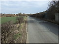
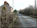
Station Lane
Heading north east towards New Whittington.
Image: © JThomas
Taken: 7 Mar 2015
0.17 miles
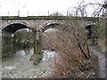
10
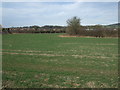
River Rother by railway bridge
A bend in the river as it exits from the railway bridge, passing extensive sewage works on the left.
Image: © Andrew Hill
Taken: 10 Jun 2011
0.18 miles