IMAGES TAKEN NEAR TO
Unstone Road, CHESTERFIELD, S41 9QS
Introduction
This page details the photographs taken nearby to Unstone Road, S41 9QS by members of the Geograph project.
The Geograph project started in 2005 with the aim of publishing, organising and preserving representative images for every square kilometre of Great Britain, Ireland and the Isle of Man.

There are currently over 7.5m images from over14,400 individuals and you can help contribute to the project by visiting https://www.geograph.org.uk
Image Map
Images are licensed for reuse under creativecommons.org/licenses/by-sa/2.0
Notes
- Clicking on the map will re-center to the selected point.
- The higher the marker number, the further away the image location is from the centre of the postcode.
Image Listing (5 Images Found)
Images are licensed for reuse under creativecommons.org/licenses/by-sa/2.0
Image
Details
Distance
1
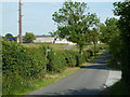
Unstone Road near Four Acres
The lane climbs towards the northern edge of Old Whittington.
Image: © Andrew Hill
Taken: 14 Jun 2011
0.01 miles
2
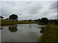
Pond at Four Acres
The Brushes, near to Old Whittington.
Image: © Peter Barr
Taken: 3 Aug 2010
0.12 miles
4
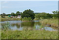
Pond at Four Acres
An attractive pond with a public footpath alongside.
Image: © Andrew Hill
Taken: 14 Jun 2011
0.13 miles
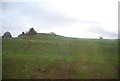
5
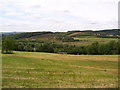
Pasture at Unstone
Submitted to the BBC Domesday Reloaded project. Looking west from Unstone Road across the railway and Sheffield Road to former NCB opencast coal site, Birch Hall. Some of the land on the far side of the valley is now a golf course. The 1986 picture has the location of the photographer as Old Whitington Lane, when it was, in fact, taken from Unstone Road. Image
Image: © Martin Speck
Taken: 1 Jul 2011
0.15 miles