IMAGES TAKEN NEAR TO
High Street, CHESTERFIELD, S41 9PU
Introduction
This page details the photographs taken nearby to High Street, S41 9PU by members of the Geograph project.
The Geograph project started in 2005 with the aim of publishing, organising and preserving representative images for every square kilometre of Great Britain, Ireland and the Isle of Man.

There are currently over 7.5m images from over14,400 individuals and you can help contribute to the project by visiting https://www.geograph.org.uk
Image Map
Images are licensed for reuse under creativecommons.org/licenses/by-sa/2.0
Notes
- Clicking on the map will re-center to the selected point.
- The higher the marker number, the further away the image location is from the centre of the postcode.
Image Listing (59 Images Found)
Images are licensed for reuse under creativecommons.org/licenses/by-sa/2.0
Image
Details
Distance
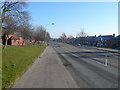
1
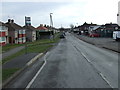
High Street Old Whittington towards Chesterfield
This is the B6052.
Image: © Andrew Tatlow
Taken: 25 Jul 2019
0.03 miles
2
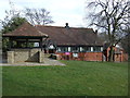
Library and information centre, Old Whittington
Image: © JThomas
Taken: 7 Mar 2015
0.04 miles
3
Old Whittington - B6052 road to Eckington
Image: © Alan Heardman
Taken: 17 Feb 2008
0.05 miles
4
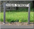
High Street sign Old Whittington
There would appear to be 3 parallel roads at this point all named Higfh Street!
Image: © Andrew Tatlow
Taken: 25 Jul 2019
0.05 miles
6
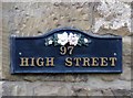
House number on 97 High Street Old Whittington
Image: © Andrew Tatlow
Taken: 25 Jul 2019
0.06 miles
7
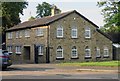
97 High Street Old Whittington
The back of the house is in the next square!
Image: © Andrew Tatlow
Taken: 25 Jul 2019
0.06 miles
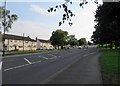
8
Station Lane, Old Whittington
Heading south east.
Image: © JThomas
Taken: 7 Mar 2015
0.07 miles
9
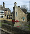
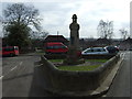
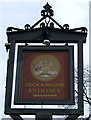
War Memorial, Old Whittington
Cock & Magpie public house behind.
Image: © JThomas
Taken: 7 Mar 2015
0.07 miles