IMAGES TAKEN NEAR TO
May Avenue, CHESTERFIELD, S41 9LW
Introduction
This page details the photographs taken nearby to May Avenue, S41 9LW by members of the Geograph project.
The Geograph project started in 2005 with the aim of publishing, organising and preserving representative images for every square kilometre of Great Britain, Ireland and the Isle of Man.

There are currently over 7.5m images from over14,400 individuals and you can help contribute to the project by visiting https://www.geograph.org.uk
Image Map
Images are licensed for reuse under creativecommons.org/licenses/by-sa/2.0
Notes
- Clicking on the map will re-center to the selected point.
- The higher the marker number, the further away the image location is from the centre of the postcode.
Image Listing (8 Images Found)
Images are licensed for reuse under creativecommons.org/licenses/by-sa/2.0
Image
Details
Distance
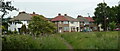
1
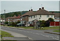
Burnbank Road, New Whittington
Looking past the junction with May Avenue.
Image: © Andrew Hill
Taken: 10 Jun 2011
0.06 miles
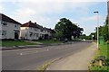
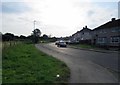
5
Footpath to Burnbridge Road
View from a footpath from Station Lane.
Image: © Andrew Hill
Taken: 10 Jun 2011
0.18 miles
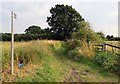
7
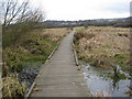
Walkway through the Wetlands
Nature Reserve off Station Lane.
Image: © Alan Heardman
Taken: 10 Mar 2009
0.20 miles
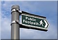
8
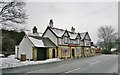
The White Horse
This pub's feeling under the weather, and all boarded up. They might welcome an offer.
Image: © Chris Morgan
Taken: 23 Jan 2013
0.25 miles