IMAGES TAKEN NEAR TO
High Street, CHESTERFIELD, S41 9LG
Introduction
This page details the photographs taken nearby to High Street, S41 9LG by members of the Geograph project.
The Geograph project started in 2005 with the aim of publishing, organising and preserving representative images for every square kilometre of Great Britain, Ireland and the Isle of Man.

There are currently over 7.5m images from over14,400 individuals and you can help contribute to the project by visiting https://www.geograph.org.uk
Image Map
Images are licensed for reuse under creativecommons.org/licenses/by-sa/2.0
Notes
- Clicking on the map will re-center to the selected point.
- The higher the marker number, the further away the image location is from the centre of the postcode.
Image Listing (18 Images Found)
Images are licensed for reuse under creativecommons.org/licenses/by-sa/2.0
Image
Details
Distance
1
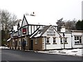
A very white White Horse
A January snowfall has made this pub even whiter than usual
Image: © Graham Hogg
Taken: 23 Jan 2013
0.08 miles
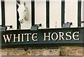
2
The White Horse
This pub's feeling under the weather, and all boarded up. They might welcome an offer.
Image: © Chris Morgan
Taken: 23 Jan 2013
0.09 miles
4
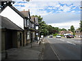
New Whittington - The White Horse
High Street view.
Image: © Alan Heardman
Taken: 27 Jun 2008
0.09 miles
5
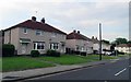
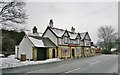
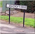
Houses on Ashcroft Drive
The nearest house is number 113 and the odd numbers decrease into the distance.
Image: © Andrew Tatlow
Taken: 25 Jul 2019
0.10 miles
6
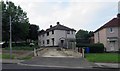
115 Ashcroft Drive/35 Oak Bank Avenue
Seems odd that a pair of semi-detached houses should be on different streets!
Image: © Andrew Tatlow
Taken: 25 Jul 2019
0.10 miles
7
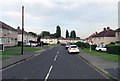
Ashcroft Drive eastwards
Typical 1950s housing estate for the area built by the local council or the Coal Board.
Image: © Andrew Tatlow
Taken: 25 Jul 2019
0.10 miles
8
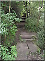
New Whittington - Footpath View of Brook Crossing and Steps
Image: © Alan Heardman
Taken: 27 Jun 2008
0.11 miles
10
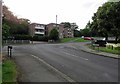
Ashcroft Drive/Oak Bank Avenue junction
Image: © Andrew Tatlow
Taken: 25 Jul 2019
0.12 miles