IMAGES TAKEN NEAR TO
Gipsy Lane, CHESTERFIELD, S41 9JE
Introduction
This page details the photographs taken nearby to Gipsy Lane, S41 9JE by members of the Geograph project.
The Geograph project started in 2005 with the aim of publishing, organising and preserving representative images for every square kilometre of Great Britain, Ireland and the Isle of Man.

There are currently over 7.5m images from over14,400 individuals and you can help contribute to the project by visiting https://www.geograph.org.uk
Image Map (Loading...)


Getting Data...Please wait
Leaflet Map data © OpenStreetMap
Images are licensed for reuse under creativecommons.org/licenses/by-sa/2.0
Notes
- Clicking on the map will re-center to the selected point.
- The higher the marker number, the further away the image location is from the centre of the postcode.
Image Listing (7 Images Found)
Images are licensed for reuse under creativecommons.org/licenses/by-sa/2.0
Image
Details
Distance
2
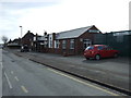
Old Whittington Miners Welfare Club
On Station Lane.
Image: © JThomas
Taken: 7 Mar 2015
0.20 miles
3
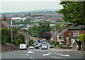
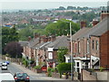
Looking down Whittington Hill
View down the B6052 towards Chesterfield.
Image: © Andrew Hill
Taken: 10 Jun 2011
0.22 miles
4
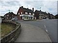
Corner of Whittington Hill and Holland Road
Houses and a corner shop on the B6052 in Old Whittington.
Image: © Andrew Hill
Taken: 10 Jun 2011
0.23 miles
5
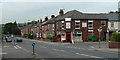
Houses on Whittington Hill
Terraced houses by the B6052 towards Chesterfield.
Image: © Andrew Hill
Taken: 10 Jun 2011
0.23 miles

7
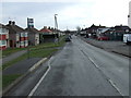
Station Lane, Old Whittington
Heading south east.
Image: © JThomas
Taken: 7 Mar 2015
0.24 miles