IMAGES TAKEN NEAR TO
Whitting Valley Road, CHESTERFIELD, S41 9EY
Introduction
This page details the photographs taken nearby to Whitting Valley Road, S41 9EY by members of the Geograph project.
The Geograph project started in 2005 with the aim of publishing, organising and preserving representative images for every square kilometre of Great Britain, Ireland and the Isle of Man.

There are currently over 7.5m images from over14,400 individuals and you can help contribute to the project by visiting https://www.geograph.org.uk
Image Map (Loading...)


Getting Data...Please wait
Leaflet Map data © OpenStreetMap
Images are licensed for reuse under creativecommons.org/licenses/by-sa/2.0
Notes
- Clicking on the map will re-center to the selected point.
- The higher the marker number, the further away the image location is from the centre of the postcode.
Image Listing (7 Images Found)
Images are licensed for reuse under creativecommons.org/licenses/by-sa/2.0
Image
Details
Distance
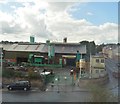
2
Whittington Rail Bridge
The bridge over Brimington Road North in Whittington Moor, Derbyshire.
Image: © Gordon Griffiths
Taken: 21 Sep 2013
0.23 miles
3
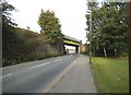
Whittington Rail Bridge View
The bridge over Brimington Road North in Whittington Moor, Derbyshire.
Image: © Gordon Griffiths
Taken: 21 Sep 2013
0.24 miles
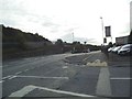
6
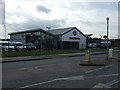
Harley Davidson motorcycle dealers
On Station Road.
Image: © JThomas
Taken: 7 Mar 2015
0.25 miles
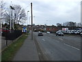
7
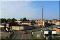
Thompson Street and Webster's Scrap Metals, Chesterfield
Image: © Roy Hughes
Taken: 18 Sep 2021
0.25 miles