IMAGES TAKEN NEAR TO
Laurence Close, CHESTERFIELD, S41 9EE
Introduction
This page details the photographs taken nearby to Laurence Close, S41 9EE by members of the Geograph project.
The Geograph project started in 2005 with the aim of publishing, organising and preserving representative images for every square kilometre of Great Britain, Ireland and the Isle of Man.

There are currently over 7.5m images from over14,400 individuals and you can help contribute to the project by visiting https://www.geograph.org.uk
Image Map
Images are licensed for reuse under creativecommons.org/licenses/by-sa/2.0
Notes
- Clicking on the map will re-center to the selected point.
- The higher the marker number, the further away the image location is from the centre of the postcode.
Image Listing (54 Images Found)
Images are licensed for reuse under creativecommons.org/licenses/by-sa/2.0
Image
Details
Distance
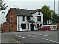
1
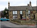
Cock & Magpie Inn, Old Whittington, Chesterfield
Image: © Andrew Loughran
Taken: 14 Feb 2006
0.08 miles
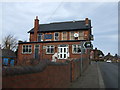
2
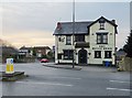
The Bull's Head, Old Whittington
Pub on the corner of Whittington Hill and Broomhill Road
Image: © Paul Harrop
Taken: 11 Nov 2017
0.10 miles
3
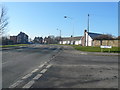
Old Whittington - B6052 junction with Church Street North
Image: © Alan Heardman
Taken: 17 Feb 2008
0.10 miles
4
Bull's Head pub, Old Whittington
On the corner of the main B6052 and Broomhill Road.
Image: © Andrew Hill
Taken: 10 Jun 2011
0.10 miles
6
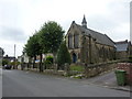
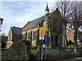
Seventh Day Adventist Church
Old Whittington, Chesterfield.
Image: © Peter Barr
Taken: 3 Aug 2010
0.12 miles
7
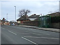
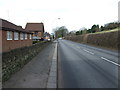
Bus stop and shelter on Whittington Hill
Opposite the Bulls Head public house.
Image: © JThomas
Taken: 7 Mar 2015
0.13 miles
9
Seventh Day Adventist Church, Old Whittington
Image: © JThomas
Taken: 7 Mar 2015
0.13 miles