IMAGES TAKEN NEAR TO
Prospect Road, CHESTERFIELD, S41 9DU
Introduction
This page details the photographs taken nearby to Prospect Road, S41 9DU by members of the Geograph project.
The Geograph project started in 2005 with the aim of publishing, organising and preserving representative images for every square kilometre of Great Britain, Ireland and the Isle of Man.

There are currently over 7.5m images from over14,400 individuals and you can help contribute to the project by visiting https://www.geograph.org.uk
Image Map
Images are licensed for reuse under creativecommons.org/licenses/by-sa/2.0
Notes
- Clicking on the map will re-center to the selected point.
- The higher the marker number, the further away the image location is from the centre of the postcode.
Image Listing (23 Images Found)
Images are licensed for reuse under creativecommons.org/licenses/by-sa/2.0
Image
Details
Distance
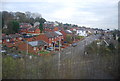
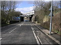
2

View from Prospect Road at Junction with B6057
Image: © Alan Heardman
Taken: 11 May 2008
0.03 miles
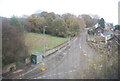
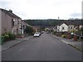
4
Old Whittington
A view from the railway line of houses on William Street North. On the right is Holland Road; on the left is a crossroads with Prospect Road.
Image: © Derek Harper
Taken: 3 Jan 2013
0.06 miles
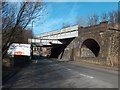
6
Billboards and Bridge
The Midland mainline crosses the road at an unusual angle and as a result has some extra steel work to hold it up.
Image: © Michael Patterson
Taken: 11 Apr 2006
0.07 miles
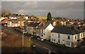
7
View across Prospect Road at Junction with B6057
Image: © Alan Heardman
Taken: 11 May 2008
0.08 miles
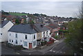
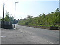
9

View across Broomhill Road at Junction with B6057
Image: © Alan Heardman
Taken: 11 May 2008
0.09 miles
10
Railway bridge over Sheffield Road, Old Whittington
Image: © Neil Theasby
Taken: 6 Mar 2012
0.10 miles