IMAGES TAKEN NEAR TO
Brimington Road North, CHESTERFIELD, S41 9BE
Introduction
This page details the photographs taken nearby to Brimington Road North, S41 9BE by members of the Geograph project.
The Geograph project started in 2005 with the aim of publishing, organising and preserving representative images for every square kilometre of Great Britain, Ireland and the Isle of Man.

There are currently over 7.5m images from over14,400 individuals and you can help contribute to the project by visiting https://www.geograph.org.uk
Image Map
Images are licensed for reuse under creativecommons.org/licenses/by-sa/2.0
Notes
- Clicking on the map will re-center to the selected point.
- The higher the marker number, the further away the image location is from the centre of the postcode.
Image Listing (23 Images Found)
Images are licensed for reuse under creativecommons.org/licenses/by-sa/2.0
Image
Details
Distance
1
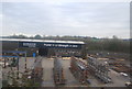
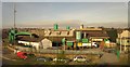
Concrete Works
The view in Brimington Road North in Whittington Moor, Derbyshire.
Image: © Gordon Griffiths
Taken: 20 Sep 2013
0.05 miles
2
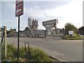
Pottery Lane East, Whittington Moor
From the railway line between Sheffield and Chesterfield. On the right is the Junction Inn. A terrace on Pottery Lane curves towards the T junction with the B6050. The concrete works on the left is across it.
Image: © Derek Harper
Taken: 3 Jan 2013
0.08 miles
3
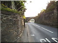
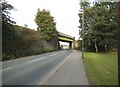
Bridge View
The Railway bridge over Brimington Road North in Whittington Moor, Derbyshire.
Image: © Gordon Griffiths
Taken: 21 Sep 2013
0.08 miles
5
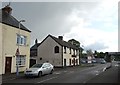
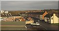
"The Junction" public house, Whittington Moor
Image: © Neil Theasby
Taken: 19 May 2015
0.11 miles
7
Whittington Rail Bridge View
The bridge over Brimington Road North in Whittington Moor, Derbyshire.
Image: © Gordon Griffiths
Taken: 21 Sep 2013
0.16 miles
8
Foundry, Whittington Moor
This firm on the corner of Eastside Road (foreground) and Pottery Lane East makes steel castings, though the address on their website is just across the A61.
Image: © Derek Harper
Taken: 6 Apr 2012
0.17 miles
9
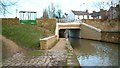
Chesterfield Canal
The road above is the Brimington-Whittington Moor road. Work on the Chesterfield canal started in October 1771 and the entire canal (which ran from Chesterfield to the River Trent north of Gainsborough) was officially opened in June 1777. The chief engineer was James Brindley but, unfortunately, he died shortly after construction began and his deputy, John Varley, was asked to take over. Subsequently the building of the canal was not without controversy. In October 1907 the Chesterfield to Norbury section was cut off from the rest of the network when the roof of Norwood Tunnel collapsed and was not reopened. Today, volunteers are working to restore the canal and there is even talk of connecting the Chesterfield to Norbury section to the South Yorkshire Navigation by making the River Rother navigable between Killamarsh and Rotherham.
Image: © Alan Walker
Taken: 5 Feb 2004
0.17 miles