IMAGES TAKEN NEAR TO
Stand Road, CHESTERFIELD, S41 8SW
Introduction
This page details the photographs taken nearby to Stand Road, S41 8SW by members of the Geograph project.
The Geograph project started in 2005 with the aim of publishing, organising and preserving representative images for every square kilometre of Great Britain, Ireland and the Isle of Man.

There are currently over 7.5m images from over14,400 individuals and you can help contribute to the project by visiting https://www.geograph.org.uk
Image Map
Images are licensed for reuse under creativecommons.org/licenses/by-sa/2.0
Notes
- Clicking on the map will re-center to the selected point.
- The higher the marker number, the further away the image location is from the centre of the postcode.
Image Listing (36 Images Found)
Images are licensed for reuse under creativecommons.org/licenses/by-sa/2.0
Image
Details
Distance
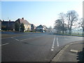
1
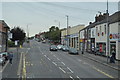
Avenue Road Whittington Moor
This view shows the end of Avenue Road where it joins Whittington Moor. It was a thriving area on the A61 between Chesterfield and Sheffield until a bypass destroyed most of it.
The building in the picture (where I was born) was two houses adjoining the corner shop where my family ran an electrical and TV shop with an adjoining cycle shop many years ago.
Image: © Philip Thompson
Taken: 26 Aug 1998
0.13 miles
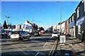
3
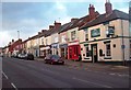
Shops and Pub on Sheffield Road, Chesterfield
The Derby Tup on the right of picture is a particularly popular real ale pub.
Image: © Jonathan Clitheroe
Taken: 27 Nov 2011
0.13 miles
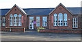
6
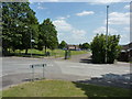
Recreation ground at Stand Road, Chesterfield
Image: © Peter Barr
Taken: 28 Jun 2010
0.14 miles
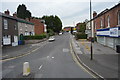
7
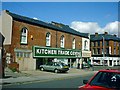
Station Road, Whittington Moor
An early February afternoon view of this busy shopping area.
Image: © Mary and Angus Hogg
Taken: 7 Feb 2014
0.15 miles
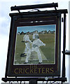
10
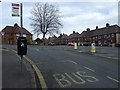
Bus stop on Peveril Road, Newbold
Outside the Cricketers Inn public house.
Image: © JThomas
Taken: 7 Mar 2015
0.16 miles