IMAGES TAKEN NEAR TO
Peveril Road, CHESTERFIELD, S41 8RW
Introduction
This page details the photographs taken nearby to Peveril Road, S41 8RW by members of the Geograph project.
The Geograph project started in 2005 with the aim of publishing, organising and preserving representative images for every square kilometre of Great Britain, Ireland and the Isle of Man.

There are currently over 7.5m images from over14,400 individuals and you can help contribute to the project by visiting https://www.geograph.org.uk
Image Map
Images are licensed for reuse under creativecommons.org/licenses/by-sa/2.0
Notes
- Clicking on the map will re-center to the selected point.
- The higher the marker number, the further away the image location is from the centre of the postcode.
Image Listing (37 Images Found)
Images are licensed for reuse under creativecommons.org/licenses/by-sa/2.0
Image
Details
Distance
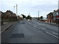
1
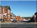
Nelson Street, Chesterfield
If vehicles weren't restricted to access only, this would be a rat run between Peveril Road and Sheffield Road.
Image: © Christine Johnstone
Taken: 18 Oct 2018
0.04 miles
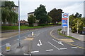
2
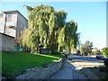
Peveril Road, Chesterfield
With a fine weeping willow below the flats in Flamsteed Crescent.
Image: © Christine Johnstone
Taken: 18 Oct 2018
0.07 miles
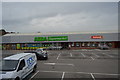
4

Chesterfield : Iceland
Iceland is next door to the ASDA on Sheffield Road.
Image: © Lewis Clarke
Taken: 2 Oct 2018
0.08 miles
5
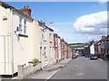
Nelson Street, Chesterfield
Nelson Street looking towards the Dema redevelopment site.
Image: © Martin Speck
Taken: 30 Jul 2009
0.09 miles
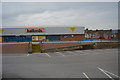
9

Chesterfield : Halfords
A Halfords on Sheffield Road.
Image: © Lewis Clarke
Taken: 2 Oct 2018
0.11 miles
10
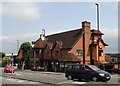
"Donkey Derby" pub-restaurant, Chesterfield
Image: © Neil Theasby
Taken: 30 Jul 2014
0.11 miles