IMAGES TAKEN NEAR TO
Winchester Road, CHESTERFIELD, S41 8QY
Introduction
This page details the photographs taken nearby to Winchester Road, S41 8QY by members of the Geograph project.
The Geograph project started in 2005 with the aim of publishing, organising and preserving representative images for every square kilometre of Great Britain, Ireland and the Isle of Man.

There are currently over 7.5m images from over14,400 individuals and you can help contribute to the project by visiting https://www.geograph.org.uk
Image Map
Images are licensed for reuse under creativecommons.org/licenses/by-sa/2.0
Notes
- Clicking on the map will re-center to the selected point.
- The higher the marker number, the further away the image location is from the centre of the postcode.
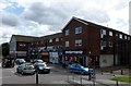
Image Listing (15 Images Found)
Images are licensed for reuse under creativecommons.org/licenses/by-sa/2.0
Image
Details
Distance
1
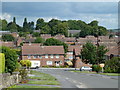
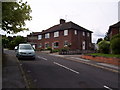
Lansdowne Avenue, Newbold
View down the northern end of the residential street with views beyond across the Newbold area of Chesterfield.
Image: © Andrew Hill
Taken: 20 Jun 2011
0.09 miles
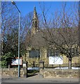


9
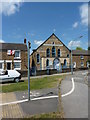
Littlemoor Gospel Chapel
Newbold, Chesterfield.
Image: © Peter Barr
Taken: 28 Jun 2010
0.19 miles
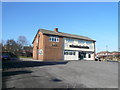
10
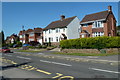
Houses on Dunston Lane, Newbold
Houses opposite Dunston Primary School.
Image: © Andrew Hill
Taken: 3 Jun 2011
0.22 miles