IMAGES TAKEN NEAR TO
Levens Way, CHESTERFIELD, S41 8HZ
Introduction
This page details the photographs taken nearby to Levens Way, S41 8HZ by members of the Geograph project.
The Geograph project started in 2005 with the aim of publishing, organising and preserving representative images for every square kilometre of Great Britain, Ireland and the Isle of Man.

There are currently over 7.5m images from over14,400 individuals and you can help contribute to the project by visiting https://www.geograph.org.uk
Image Map
Images are licensed for reuse under creativecommons.org/licenses/by-sa/2.0
Notes
- Clicking on the map will re-center to the selected point.
- The higher the marker number, the further away the image location is from the centre of the postcode.
Image Listing (15 Images Found)
Images are licensed for reuse under creativecommons.org/licenses/by-sa/2.0
Image
Details
Distance

4
Stand Road, Chesterfield.
Here we are looking in an easterly direction towards Whittington Moor and beyond.
Image: © Andrew Loughran
Taken: 4 Mar 2006
0.17 miles
5
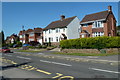
Houses on Dunston Lane, Newbold
Houses opposite Dunston Primary School.
Image: © Andrew Hill
Taken: 3 Jun 2011
0.19 miles
6

Open space off Coniston Road, Newbold
Divided into two roughly equal halves by Lindale Road (foreground).
Image: © Richard Vince
Taken: 7 Jan 2017
0.21 miles

8

Coniston Road in Dunston
A north western suburb of Chesterfield.
Image: © Jonathan Clitheroe
Taken: 10 Nov 2012
0.22 miles