IMAGES TAKEN NEAR TO
Orwins Close, CHESTERFIELD, S41 8AQ
Introduction
This page details the photographs taken nearby to Orwins Close, S41 8AQ by members of the Geograph project.
The Geograph project started in 2005 with the aim of publishing, organising and preserving representative images for every square kilometre of Great Britain, Ireland and the Isle of Man.

There are currently over 7.5m images from over14,400 individuals and you can help contribute to the project by visiting https://www.geograph.org.uk
Image Map
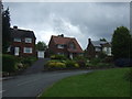
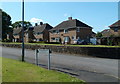
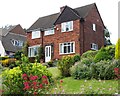
Images are licensed for reuse under creativecommons.org/licenses/by-sa/2.0
Notes
- Clicking on the map will re-center to the selected point.
- The higher the marker number, the further away the image location is from the centre of the postcode.
Image Listing (20 Images Found)
Images are licensed for reuse under creativecommons.org/licenses/by-sa/2.0
Image
Details
Distance
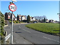
2
Newbold Road (B6051)
Heading south east towards Chesterfield.
Image: © JThomas
Taken: 24 May 2014
0.11 miles
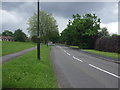
3
Chesterfield : Newbold Road B6051
Heading along Newbold Road.
Image: © Lewis Clarke
Taken: 1 Oct 2018
0.12 miles
4
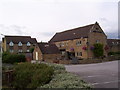
The Old House
The Old House on Old House Road, Chesterfield.
Image: © Martin Speck
Taken: 29 Jul 2010
0.14 miles
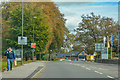
6

Chesterfield : Newbold Road B6051
A road approaches a Co-op store.
Image: © Lewis Clarke
Taken: 1 Oct 2018
0.14 miles
7
Thirlmere Road, Newbold
A residential street off Ulverston Road.
Image: © Andrew Hill
Taken: 3 Jun 2011
0.15 miles
9
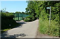
Newbold Back Lane
This must once have been a country lane, now tucked between the modern B6150 and school grounds.
Image: © Andrew Hill
Taken: 3 Jun 2011
0.16 miles
10
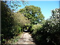
Newbold Back Lane, Newbold
Looking north. The surrounding area has been developed since the 1940s, but this lane remains almost untouched.
Image: © Christine Johnstone
Taken: 18 Oct 2018
0.17 miles