IMAGES TAKEN NEAR TO
Brimington Road, CHESTERFIELD, S41 7UZ
Introduction
This page details the photographs taken nearby to Brimington Road, S41 7UZ by members of the Geograph project.
The Geograph project started in 2005 with the aim of publishing, organising and preserving representative images for every square kilometre of Great Britain, Ireland and the Isle of Man.

There are currently over 7.5m images from over14,400 individuals and you can help contribute to the project by visiting https://www.geograph.org.uk
Image Map
Images are licensed for reuse under creativecommons.org/licenses/by-sa/2.0
Notes
- Clicking on the map will re-center to the selected point.
- The higher the marker number, the further away the image location is from the centre of the postcode.
Image Listing (105 Images Found)
Images are licensed for reuse under creativecommons.org/licenses/by-sa/2.0
Image
Details
Distance
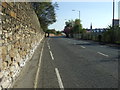
2
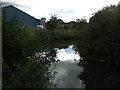
![Bridge over the River Rother [2]](https://s3.geograph.org.uk/geophotos/03/10/39/3103923_d9115cda_120x120.jpg)
Bridge over the River Rother [2]
With the Trans Pennine Trail, Cuckoo Way and Drone Valley Way passing underneath. This part of the river forms part of the Chesterfield Canal.
Image: © Christine Johnstone
Taken: 27 Aug 2012
0.02 miles
3
New canalside housing, Chesterfield
Off Brimington Road.
Image: © Christine Johnstone
Taken: 18 Oct 2018
0.02 miles
4
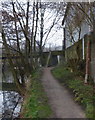
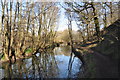
Riverside footpath parallel to Brimington Road
By the River Rother in Chesterfield, the bridge is just over the grid-line.
Image: © Andrew Hill
Taken: 5 Mar 2011
0.02 miles
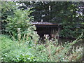
6
Industrial building by the River Rother in Chesterfield
Looking south along the riverside footpath.
Image: © Andrew Hill
Taken: 5 Mar 2011
0.03 miles
7
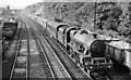
Up express approaching Chesterfield (Midland) Station
View northward, towards Sheffield, Leeds etc., from just north of Chesterfield Midland Station, with LMS 'Jubilee' 6P 4-6-0 No. 45651 'Shovell' on the 16.45 Bradford (Forster Square) to Bristol express. This four-track section of the Midland Main Line between Tapton Junction and Clay Cross was immensely busy, as all north-south main line passenger and freight traffic was funnelled through. Goods and mineral trains ran under Permissive Block on the two tracks behind the station: here can be seen a Down iron-ore train, following a light engine following another Down freight.
Image: © Ben Brooksbank
Taken: 13 Jun 1957
0.04 miles
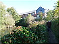
8
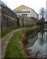
Chesterfield Canal
Trees reflect in the still waters.
Image: © Ashley Dace
Taken: 19 Mar 2011
0.04 miles
9
Merry-Go-Round Passing Castle Hill
56072 hauling a load of coal from the collieries of South Yorkshire to the power stations of the Midlands along the freight lines near Chesterfield. The woods on the right are on Castle Hill.
Image: © Martin Addison
Taken: Unknown
0.04 miles