IMAGES TAKEN NEAR TO
Sheffield Road, CHESTERFIELD, S41 7JQ
Introduction
This page details the photographs taken nearby to Sheffield Road, S41 7JQ by members of the Geograph project.
The Geograph project started in 2005 with the aim of publishing, organising and preserving representative images for every square kilometre of Great Britain, Ireland and the Isle of Man.

There are currently over 7.5m images from over14,400 individuals and you can help contribute to the project by visiting https://www.geograph.org.uk
Image Map
Images are licensed for reuse under creativecommons.org/licenses/by-sa/2.0
Notes
- Clicking on the map will re-center to the selected point.
- The higher the marker number, the further away the image location is from the centre of the postcode.
Image Listing (52 Images Found)
Images are licensed for reuse under creativecommons.org/licenses/by-sa/2.0
Image
Details
Distance
1
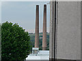
Dema Glass Chimneys
5 minutes before the chimneys come down on 20.08.2006
Image: © Paul Greenwood
Taken: 20 Aug 2006
0.02 miles
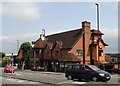
4
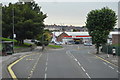
Chesters Fish & Chips
A fast food outlet on Sheffield Road with a substantial car park. It looks like a former pub.
Image: © Bill Boaden
Taken: 3 Oct 2021
0.07 miles
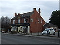
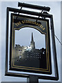
8
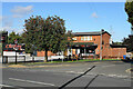
"Donkey Derby" pub-restaurant, Chesterfield
Image: © Neil Theasby
Taken: 30 Jul 2014
0.11 miles
9
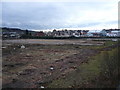
Lockoford Lane - View across cleared Dema Glass Site
Image: © Alan Heardman
Taken: 21 Feb 2007
0.12 miles
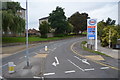
10
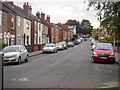
Chesterfield : James Street
Looking up James Street.
Image: © Lewis Clarke
Taken: 1 Oct 2018
0.12 miles