IMAGES TAKEN NEAR TO
Rugby Drive, CHESTERFIELD, S41 7GW
Introduction
This page details the photographs taken nearby to Rugby Drive, S41 7GW by members of the Geograph project.
The Geograph project started in 2005 with the aim of publishing, organising and preserving representative images for every square kilometre of Great Britain, Ireland and the Isle of Man.

There are currently over 7.5m images from over14,400 individuals and you can help contribute to the project by visiting https://www.geograph.org.uk
Image Map
Images are licensed for reuse under creativecommons.org/licenses/by-sa/2.0
Notes
- Clicking on the map will re-center to the selected point.
- The higher the marker number, the further away the image location is from the centre of the postcode.
Image Listing (36 Images Found)
Images are licensed for reuse under creativecommons.org/licenses/by-sa/2.0
Image
Details
Distance
4
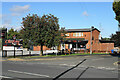
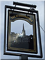
Chesters Fish & Chips
A fast food outlet on Sheffield Road with a substantial car park. It looks like a former pub.
Image: © Bill Boaden
Taken: 3 Oct 2021
0.08 miles
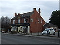
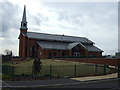
5
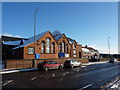
Parish Centre, Stonegravels
Sheffield Road, Chesterfield
Image: © Peter Barr
Taken: 7 Jan 2010
0.09 miles
7
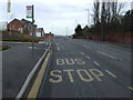
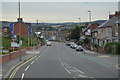
Bus stop on Sheffield Road, Stonegravels
Looking north.
Image: © JThomas
Taken: 7 Mar 2015
0.09 miles
8
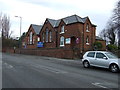
Parish Centre, Stonegravels
Built in 1870 as a Church of England Primary School.
Image: © JThomas
Taken: 7 Mar 2015
0.10 miles
9
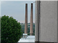
Dema Glass Chimneys
5 minutes before the chimneys come down on 20.08.2006
Image: © Paul Greenwood
Taken: 20 Aug 2006
0.12 miles