IMAGES TAKEN NEAR TO
Gratton Place, S41 7FF
Introduction
This page details the photographs taken nearby to Gratton Place, S41 7FF by members of the Geograph project.
The Geograph project started in 2005 with the aim of publishing, organising and preserving representative images for every square kilometre of Great Britain, Ireland and the Isle of Man.

There are currently over 7.5m images from over14,400 individuals and you can help contribute to the project by visiting https://www.geograph.org.uk
Image Map
Images are licensed for reuse under creativecommons.org/licenses/by-sa/2.0
Notes
- Clicking on the map will re-center to the selected point.
- The higher the marker number, the further away the image location is from the centre of the postcode.
Image Listing (87 Images Found)
Images are licensed for reuse under creativecommons.org/licenses/by-sa/2.0
Image
Details
Distance
1
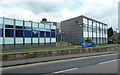
University of Derby - Chesterfield
An extension of the university providing mainly health education courses. On the corner of Canal Wharf and Hazelhurst Avenue.
Image: © Andrew Hill
Taken: 20 Jun 2011
0.02 miles
2
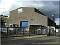
Eriks, Chesterfield
This company specialises in electrical equipment - especially motor rewinds and repairs.
Image: © Chris Allen
Taken: 27 Aug 2017
0.06 miles
4

Precious metals
If you're thinking of nicking anything here, mate, you needn't bother
Image: © Peter Barr
Taken: 7 Jan 2010
0.08 miles
5
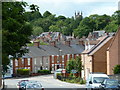
Canal Wharf towards Chesterfield town centre
New flats on the right with traditional terraces on Wharf Lane ahead. The church on the skyline is Holy Trinity on the B6051 Newbold Road.
Image: © Andrew Hill
Taken: 20 Jun 2011
0.09 miles
6
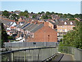
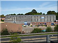
Chesterfield houses from the foot bridge
A view from the foot bridge over the main dual carriageway through Chesterfield
Image: © Chris Allen
Taken: 27 Aug 2017
0.09 miles
7
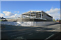
New warehouse on Sheffield Road
A new warehouse is being constructed for the supply of building materials including a trade counter.
Image: © Bill Boaden
Taken: 3 Oct 2021
0.10 miles
8
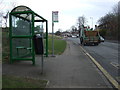
Bus stop and shelter on Sheffield Road, Stonegravels
Looking north.
Image: © JThomas
Taken: 7 Mar 2015
0.10 miles
9
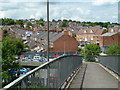
Footbridge view to Wharf Lane
View from a footbridge over the A61 to a residential area north of the town centre. The terrace line leading leftwards is on Wharf Lane.
Image: © Andrew Hill
Taken: 20 Jun 2011
0.11 miles
10
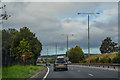
Chesterfield : The A61 Rother Way
Heading along Rother Way.
Image: © Lewis Clarke
Taken: 30 Sep 2018
0.11 miles