IMAGES TAKEN NEAR TO
Poppy Crescent, CHESTERFIELD, S41 0UL
Introduction
This page details the photographs taken nearby to Poppy Crescent, S41 0UL by members of the Geograph project.
The Geograph project started in 2005 with the aim of publishing, organising and preserving representative images for every square kilometre of Great Britain, Ireland and the Isle of Man.

There are currently over 7.5m images from over14,400 individuals and you can help contribute to the project by visiting https://www.geograph.org.uk
Image Map
Images are licensed for reuse under creativecommons.org/licenses/by-sa/2.0
Notes
- Clicking on the map will re-center to the selected point.
- The higher the marker number, the further away the image location is from the centre of the postcode.
Image Listing (46 Images Found)
Images are licensed for reuse under creativecommons.org/licenses/by-sa/2.0
Image
Details
Distance
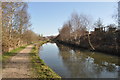
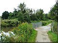
2
Development site near Ryecroft Farm, Chesterfield
A small stream is fenced off. The site is on the east bank of the Chesterfield Canal.
Image: © Christine Johnstone
Taken: 18 Oct 2018
0.10 miles
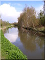
3
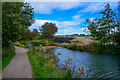
Chesterfield : Chesterfield Canal
The Chesterfield Canal is a narrow canal in the East Midlands of England and it is known locally as 'Cuckoo Dyke'.
Image: © Lewis Clarke
Taken: 2 Oct 2018
0.11 miles
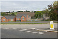
4
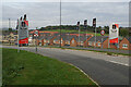
Heritage Green
A new housing estate off the A619.
Image: © Bill Boaden
Taken: 16 Oct 2021
0.11 miles
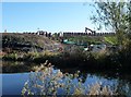
5
Bridge over overflow weir, Chesterfield Canal
The overflow passes into Tinkers Sink, which itself is soon absorbed by the River Rother.
Image: © Christine Johnstone
Taken: 27 Aug 2012
0.12 miles
7
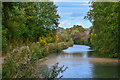
Chesterfield : Chesterfield Canal
It was one of the last of the canals designed by James Brindley, who died while it was being constructed. It was opened in 1777 and ran for 46 miles (74 km) from the River Trent at West Stockwith, Nottinghamshire to Chesterfield, Derbyshire, passing through the Norwood Tunnel at Kiveton Park, at the time one of the longest tunnels on the British canal system.
Image: © Lewis Clarke
Taken: 2 Oct 2018
0.12 miles
8
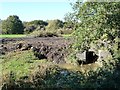
Brick culvert over a stream called Tinker Sink
One of the few remains of a dismantled railway line, parallel to the Chesterfield Canal.
Image: © Christine Johnstone
Taken: 18 Oct 2018
0.12 miles
9
New houses at Heritage Green
Behind are fields leading up to Brimington.
Image: © Bill Boaden
Taken: 16 Oct 2021
0.12 miles
10
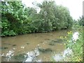
The Chesterfield Canal
There are few boats on this navigable but isolated stretch, so the water is muddy and weedy.
Image: © Christine Johnstone
Taken: 27 Aug 2012
0.13 miles