IMAGES TAKEN NEAR TO
Calow Lane, CHESTERFIELD, S41 0TU
Introduction
This page details the photographs taken nearby to Calow Lane, S41 0TU by members of the Geograph project.
The Geograph project started in 2005 with the aim of publishing, organising and preserving representative images for every square kilometre of Great Britain, Ireland and the Isle of Man.

There are currently over 7.5m images from over14,400 individuals and you can help contribute to the project by visiting https://www.geograph.org.uk
Image Map
Images are licensed for reuse under creativecommons.org/licenses/by-sa/2.0
Notes
- Clicking on the map will re-center to the selected point.
- The higher the marker number, the further away the image location is from the centre of the postcode.
Image Listing (19 Images Found)
Images are licensed for reuse under creativecommons.org/licenses/by-sa/2.0
Image
Details
Distance
1
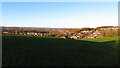
Un-defined field path northwest of Laurel Farm with a view towards Chesterfield
Image: © Colin Park
Taken: 2 Dec 2021
0.04 miles
2
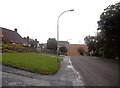
Spital Lane in Chesterfield
Spital Lane runs parallel with the brook of the same name and is seen here approaching the junction with Calow Lane. The ploughed farmland in the distance (and on the other side of the local authority boundary) is Furnace Hillock.
Image: © Jonathan Clitheroe
Taken: 25 Sep 2012
0.04 miles
3
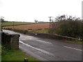
Bridge Over Spital Brook
This bridge is situated on Calow Lane and is pictured here on a persistently wet Tuesday in late September. The dwelling on the horizon (occupying the northern edge of this grid square) is Laurel Farm and the green box on the far left of picture is a water-level gauge.
Image: © Jonathan Clitheroe
Taken: 25 Sep 2012
0.05 miles
4
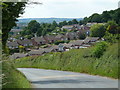
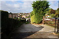
Calow Lane towards the fringe of Chesterfield
The houses are on Hady Lane.
Image: © Andrew Hill
Taken: 20 Jun 2011
0.07 miles
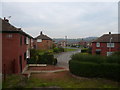
6
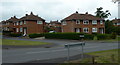
Houses by Calow Lane
Part of a housing estate near Calow Brook.
Image: © Andrew Hill
Taken: 23 May 2011
0.11 miles
7
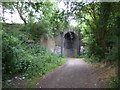
A disused railway bridge with graffiti
Dingle Bank, south east of Hady, Chesterfield.
Image: © Peter Barr
Taken: 7 Jul 2010
0.12 miles
8
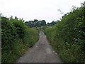
Bridleway to Calow
This bridleway leads to Calow emerging from the fields close to the hospital.
Image: © Michael Patterson
Taken: 28 Jun 2006
0.13 miles
9
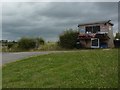
Duck and quail eggs are under the flap
A self-service country produce shed, with security lighting and CCTV, Calow.
Image: © Peter Barr
Taken: 7 Jul 2010
0.13 miles
10
Heathcote Drive
View from Calow Lane.
Image: © Alan Heardman
Taken: 22 Oct 2007
0.16 miles